Łubowo geodata
Łubowo (West Pomerania) is a populated place; located in Poland in Europe/Warsaw (GMT+2) time zone. With population of 1,300 people, there are 2055 cities with bigger population in this country. Compared to other cities in Poland, 90.5% of cities are located further ↓South; 90.1% of cities are located further →East and 59.5% of cities have higher elevation than Łubowo. Note1
Administrative division(s):
- Level 1: West Pomerania
- Level 2: Powiat szczecinecki
- Level 3: Borne Sulinowo


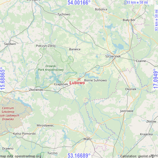
Łubowo GPS coordinates[2]
53° 35' 10.824" North, 16° 23' 30.372" East
| Map corner | latitude | longitude |
|---|---|---|
| Upper-left | 54.00166°, | 15.68865° |
| Center: | 53.58634°, | 16.39177° |
| Lower-right: | 53.16689°, | 17.0949° |
| Map W x H: | 92.8×92.8 km | = 57.7×57.7mi |
| max Lat: | 54.83135° ⇑9.5% North |
| Łubowo: | 53.58634° |
| min Lat: | ⇓90.5% South 49.21328° |
| min Long | Łubowo | max Long |
| 14.20249° | 16.39177° | 24.03723° |
| W 9.9%⇐ | ⇒90.1% E |
Elevation
Elevation of Łubowo is 148 m = 486 ft, and this is 43.4 m = 142 ft below average elevation for this country.
| Max E: |
974 m = 3196 ft | 59.5% |
| Avg. | 191.4 m = 628 ft | |
| Łubowo | 148 m = 486 ft | |
Min E: |
-3 m = -10 ft | 40.5% |
See also: Poland elevation on elevation.city.
Geographical zone
Łubowo is located in North temperate zone (between Tropic of Cancer and the Arctic Circle). Distance of this North polar circle is 1442.9 km =896.6 mi to North.| Distance of | km | miles | from Łubowo |
|---|---|---|---|
| North Pole | 4048.8 | 2515.8 | to North |
| Arctic Circle | 1442.9 | 896.6 | to North |
| Tropic Cancer | 3352.3 | 2083 | to South |
| Equator | 5958.2 | 3702.3 | to South |


Nearby cities:
15 places around Łubowo: (largest is in red/bold)
• Barwice
17.8 km =11.1 mi,  352°
352°
• Borne Sulinowo
9.4 km =5.8 mi,  96°
96°
• Czaplinek
10.9 km =6.8 mi,  253°
253°
• Grzmiąca
28.1 km =17.5 mi,  5°
5°
• Jastrowie
33.7 km =20.9 mi,  123°
123°
• Mirosławiec
33.9 km =21.1 mi,  216°
216°
• Okonek
30.9 km =19.2 mi, 100°
• Połczyn-Zdrój
27.8 km =17.3 mi,  315°
315°
• Sitno
19.7 km =12.2 mi,  66°
66°
• Sypniewo
19.3 km =12 mi,  132°
132°
• Szczecinek
24.4 km =15.2 mi,  56°
56°
• Wałcz
34.7 km =21.6 mi,  171°
171°
• Wierzchowo
23.9 km =14.9 mi,  233°
233°
• Złocieniec
25.8 km =16 mi,  256°
256°
• Żółtnica
29.2 km =18.1 mi, 70°
Sources, notices
• [Note1] Compared only with cities in Poland existing in our database
• [Src1] Map data: © OpenStreetMap contributors (CC-BY-SA)
• [Src2] Other city data from geonames.org with taken over terms of usage.
• [Src3] Geographical zone / Annual Mean Temperature by Robert A. Rohde @ Wikipedia
