Wierzchowo geodata
Wierzchowo (West Pomerania) is a populated place; located in Poland in Europe/Warsaw (GMT+2) time zone. With population of 1,541 people, there are 1811 cities with bigger population in this country. Compared to other cities in Poland, 89.1% of cities are located further ↓South; 91.9% of cities are located further →East and 64.1% of cities have higher elevation than Wierzchowo. Note1


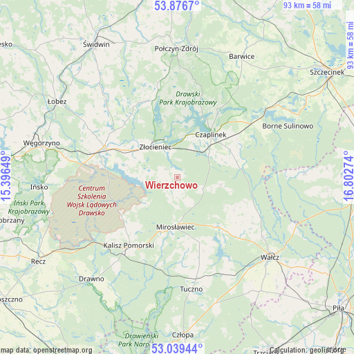
Wierzchowo GPS coordinates[2]
53° 27' 36.468" North, 16° 5' 58.596" East
| Map corner | latitude | longitude |
|---|---|---|
| Upper-left | 53.8767°, | 15.39649° |
| Center: | 53.46013°, | 16.09961° |
| Lower-right: | 53.03944°, | 16.80274° |
| Map W x H: | 93.1×93.1 km | = 57.8×57.8mi |
| max Lat: | 54.83135° ⇑10.9% North |
| Wierzchowo: | 53.46013° |
| min Lat: | ⇓89.1% South 49.21328° |
| min Long | Wierzchowo | max Long |
| 14.20249° | 16.09961° | 24.03723° |
| W 8.1%⇐ | ⇒91.9% E |
Elevation
Elevation of Wierzchowo is 136 m = 446 ft, and this is 55.4 m = 182 ft below average elevation for this country.
| Max E: |
974 m = 3196 ft | 64.1% |
| Avg. | 191.4 m = 628 ft | |
| Wierzchowo | 136 m = 446 ft | |
Min E: |
-3 m = -10 ft | 35.9% |
See also: Poland elevation on elevation.city.
Geographical zone
Wierzchowo is located in North temperate zone (between Tropic of Cancer and the Arctic Circle). Distance of this North polar circle is 1457 km =905.3 mi to North.| Distance of | km | miles | from Wierzchowo |
|---|---|---|---|
| North Pole | 4062.9 | 2524.6 | to North |
| Arctic Circle | 1457 | 905.3 | to North |
| Tropic Cancer | 3338.3 | 2074.3 | to South |
| Equator | 5944.2 | 3693.6 | to South |


Nearby cities:
15 places around Wierzchowo: (largest is in red/bold)
• Barwice
35.9 km =22.3 mi,  28°
28°
• Borne Sulinowo
31.5 km =19.6 mi,  65°
65°
• Brzeżno
33.5 km =20.8 mi,  322°
322°
• Czaplinek
14 km =8.7 mi,  39°
39°
• Drawno
35 km =21.7 mi,  220°
220°
• Drawsko Pomorskie
20.7 km =12.9 mi,  292°
292°
• Ińsko
36.5 km =22.7 mi,  265°
265°
• Kalisz Pomorski
22 km =13.7 mi, 215°
• Mirosławiec
13.3 km =8.3 mi,  183°
183°
• Połczyn-Zdrój
33.8 km =21 mi,  359°
359°
• Sypniewo
33.5 km =20.8 mi,  88°
88°
• Tuczno
29.8 km =18.5 mi,  173°
173°
• Wałcz
31.9 km =19.8 mi,  129°
129°
• Złocieniec
10 km =6.2 mi, 324°
• Łubowo
23.9 km =14.9 mi,  53°
53°
Sources, notices
• [Note1] Compared only with cities in Poland existing in our database
• [Src1] Map data: © OpenStreetMap contributors (CC-BY-SA)
• [Src2] Other city data from geonames.org with taken over terms of usage.
• [Src3] Geographical zone / Annual Mean Temperature by Robert A. Rohde @ Wikipedia
