Uniejów geodata
Uniejów (Łódź Voivodeship) is a seat of a third-order administrative division; located in Poland in Europe/Warsaw (GMT+2) time zone. With population of 2,932 people, there are 1078 cities with bigger population in this country. Compared to other cities in Poland, 65.2% of cities are located further ↓South; 63.5% of cities are located further →East and 72.6% of cities have higher elevation than Uniejów. Note1


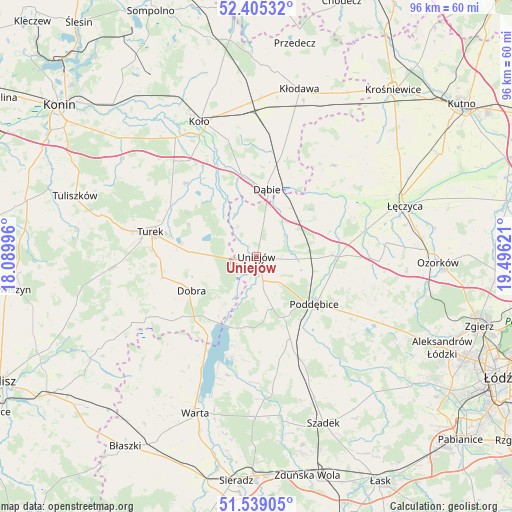
Uniejów GPS coordinates[2]
51° 58' 27.408" North, 18° 47' 35.088" East
| Map corner | latitude | longitude |
|---|---|---|
| Upper-left | 52.40532°, | 18.08996° |
| Center: | 51.97428°, | 18.79308° |
| Lower-right: | 51.53905°, | 19.49621° |
| Map W x H: | 96.3×96.3 km | = 59.8×59.8mi |
| max Lat: | 54.83135° ⇑34.8% North |
| Uniejów: | 51.97428° |
| min Lat: | ⇓65.2% South 49.21328° |
| min Long | Uniejów | max Long |
| 14.20249° | 18.79308° | 24.03723° |
| W 36.5%⇐ | ⇒63.5% E |
Elevation
Elevation of Uniejów is 116 m = 381 ft, and this is 75.4 m = 247 ft below average elevation for this country.
| Max E: |
974 m = 3196 ft | 72.6% |
| Avg. | 191.4 m = 628 ft | |
| Uniejów | 116 m = 381 ft | |
Min E: |
-3 m = -10 ft | 27.4% |
See also: Poland elevation on elevation.city.
Geographical zone
Uniejów is located in North temperate zone (between Tropic of Cancer and the Arctic Circle). Distance of this North polar circle is 1622.2 km =1008 mi to North.| Distance of | km | miles | from Uniejów |
|---|---|---|---|
| North Pole | 4228.1 | 2627.2 | to North |
| Arctic Circle | 1622.2 | 1008 | to North |
| Tropic Cancer | 3173.1 | 1971.7 | to South |
| Equator | 5779 | 3590.9 | to South |


Nearby cities:
15 places around Uniejów: (largest is in red/bold)
• Brudzew
19 km =11.8 mi,  317°
317°
• Dalików
24.5 km =15.2 mi,  114°
114°
• Dobra
13.8 km =8.6 mi,  242°
242°
• Dąbie
12.7 km =7.9 mi,  9°
9°
• Grabów
22.2 km =13.8 mi,  40°
40°
• Grzegorzew
25.6 km =15.9 mi,  350°
350°
• Kawęczyn
19.4 km =12.1 mi,  248°
248°
• Olszówka
24.5 km =15.2 mi, 11°
• Poddębice
14.4 km =8.9 mi,  128°
128°
• Przykona
12.4 km =7.7 mi,  273°
273°
• Pęczniew
19.5 km =12.1 mi,  194°
194°
• Turek
20.5 km =12.7 mi,  282°
282°
• Wartkowice
14.3 km =8.9 mi,  89°
89°
• Zadzim
22.3 km =13.9 mi,  170°
170°
• Świnice Warckie
11.3 km =7 mi,  49°
49°
Sources, notices
• [Note1] Compared only with cities in Poland existing in our database
• [Src1] Map data: © OpenStreetMap contributors (CC-BY-SA)
• [Src2] Other city data from geonames.org with taken over terms of usage.
• [Src3] Geographical zone / Annual Mean Temperature by Robert A. Rohde @ Wikipedia
