Poddębice geodata
Poddębice (Łódź Voivodeship) is a seat of a third-order administrative division; located in Poland in Europe/Warsaw (GMT+2) time zone. With population of 7,840 people, there are 511 cities with bigger population in this country. Compared to other cities in Poland, 63.5% of cities are located further ↓South; 60.7% of cities are located further →East and 67.8% of cities have higher elevation than Poddębice. Note1


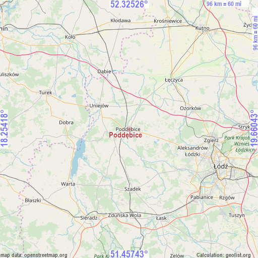
Poddębice GPS coordinates[2]
51° 53' 36.384" North, 18° 57' 26.28" East
| Map corner | latitude | longitude |
|---|---|---|
| Upper-left | 52.32526°, | 18.25418° |
| Center: | 51.89344°, | 18.9573° |
| Lower-right: | 51.45743°, | 19.66043° |
| Map W x H: | 96.5×96.5 km | = 60×60mi |
| max Lat: | 54.83135° ⇑36.5% North |
| Poddębice: | 51.89344° |
| min Lat: | ⇓63.5% South 49.21328° |
| min Long | Poddębice | max Long |
| 14.20249° | 18.9573° | 24.03723° |
| W 39.3%⇐ | ⇒60.7% E |
Elevation
Elevation of Poddębice is 126 m = 413 ft, and this is 65.4 m = 215 ft below average elevation for this country.
| Max E: |
974 m = 3196 ft | 67.8% |
| Avg. | 191.4 m = 628 ft | |
| Poddębice | 126 m = 413 ft | |
Min E: |
-3 m = -10 ft | 32.2% |
See also: Poland elevation on elevation.city.
Geographical zone
Poddębice is located in North temperate zone (between Tropic of Cancer and the Arctic Circle). Distance of this North polar circle is 1631.2 km =1013.6 mi to North.| Distance of | km | miles | from Poddębice |
|---|---|---|---|
| North Pole | 4237.1 | 2632.8 | to North |
| Arctic Circle | 1631.2 | 1013.6 | to North |
| Tropic Cancer | 3164.1 | 1966.1 | to South |
| Equator | 5770 | 3585.3 | to South |


Nearby cities:
15 places around Poddębice: (largest is in red/bold)
• Błonie
23.8 km =14.8 mi,  31°
31°
• Dalików
11.1 km =6.9 mi,  94°
94°
• Dobra
23.6 km =14.7 mi,  276°
276°
• Dąbie
23.4 km =14.5 mi,  336°
336°
• Kazimierz
22.1 km =13.7 mi,  129°
129°
• Lutomiersk
23.3 km =14.5 mi, 131°
• Ozorków
24.2 km =15 mi,  71°
71°
• Parzęczew
18.1 km =11.2 mi, 70°
• Pęczniew
18.9 km =11.7 mi,  238°
238°
• Szadek
22.5 km =14 mi,  176°
176°
• Uniejów
14.4 km =8.9 mi,  308°
308°
• Wartkowice
9.7 km =6 mi,  18°
18°
• Wodzierady
23.6 km =14.7 mi,  145°
145°
• Zadzim
15 km =9.3 mi,  209°
209°
• Świnice Warckie
16.6 km =10.3 mi,  350°
350°
Sources, notices
• [Note1] Compared only with cities in Poland existing in our database
• [Src1] Map data: © OpenStreetMap contributors (CC-BY-SA)
• [Src2] Other city data from geonames.org with taken over terms of usage.
• [Src3] Geographical zone / Annual Mean Temperature by Robert A. Rohde @ Wikipedia
