Legnickie Pole geodata
Legnickie Pole (Lower Silesia) is a populated place; located in Poland in Europe/Warsaw (GMT+2) time zone. With population of 1,301 people, there are 2053 cities with bigger population in this country. Compared to other cities in Poland, 50.8% of cities are located further ↑North; 91.2% of cities are located further →East and 50.8% of cities have higher elevation than Legnickie Pole. Note1


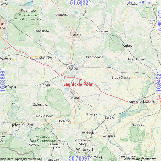
Legnickie Pole GPS coordinates[2]
51° 8' 39.084" North, 16° 14' 31.488" East
| Map corner | latitude | longitude |
|---|---|---|
| Upper-left | 51.5832°, | 15.53896° |
| Center: | 51.14419°, | 16.24208° |
| Lower-right: | 50.70097°, | 16.94521° |
| Map W x H: | 98.1×98.1 km | = 61×61mi |
| max Lat: | 54.83135° ⇑50.8% North |
| Legnickie Pole: | 51.14419° |
| min Lat: | ⇓49.2% South 49.21328° |
| min Long | Legnickie Pole | max Long |
| 14.20249° | 16.24208° | 24.03723° |
| W 8.8%⇐ | ⇒91.2% E |
Elevation
Elevation of Legnickie Pole is 170 m = 558 ft, and this is 21.4 m = 70 ft below average elevation for this country.
| Max E: |
974 m = 3196 ft | 50.8% |
| Avg. | 191.4 m = 628 ft | |
| Legnickie Pole | 170 m = 558 ft | |
Min E: |
-3 m = -10 ft | 49.2% |
See also: Poland elevation on elevation.city.
Geographical zone
Legnickie Pole is located in North temperate zone (between Tropic of Cancer and the Arctic Circle). Distance of this North polar circle is 1714.5 km =1065.3 mi to North.| Distance of | km | miles | from Legnickie Pole |
|---|---|---|---|
| North Pole | 4320.4 | 2684.6 | to North |
| Arctic Circle | 1714.5 | 1065.3 | to North |
| Tropic Cancer | 3080.8 | 1914.3 | to South |
| Equator | 5686.7 | 3533.6 | to South |


Nearby cities:
15 places around Legnickie Pole: (largest is in red/bold)
• Jawor
10.9 km =6.8 mi,  198°
198°
• Konary
15.5 km =9.6 mi,  137°
137°
• Krotoszyce
13.7 km =8.5 mi,  271°
271°
• Kunice
8.7 km =5.4 mi,  2°
2°
• Legnica
9.2 km =5.7 mi,  322°
322°
• Lisowice
17.6 km =10.9 mi,  24°
24°
• Malczyce
19.5 km =12.1 mi,  64°
64°
• Mierczyce
7.6 km =4.7 mi, 138°
• Miłkowice
17.2 km =10.7 mi, 316°
• Męcinka
12.8 km =8 mi,  232°
232°
• Paszowice
16.1 km =10 mi, 202°
• Prochowice
16.7 km =10.4 mi,  30°
30°
• Strzegom
21.6 km =13.4 mi,  159°
159°
• Udanin
19 km =11.8 mi,  128°
128°
• Wądroże Wielkie
7 km =4.3 mi,  115°
115°
Sources, notices
• [Note1] Compared only with cities in Poland existing in our database
• [Src1] Map data: © OpenStreetMap contributors (CC-BY-SA)
• [Src2] Other city data from geonames.org with taken over terms of usage.
• [Src3] Geographical zone / Annual Mean Temperature by Robert A. Rohde @ Wikipedia
