Sztum geodata
Sztum (Pomerania) is a seat of a third-order administrative division; located in Poland in Europe/Warsaw (GMT+2) time zone. With population of 9,766 people, there are 454 cities with bigger population in this country. Compared to other cities in Poland, 93.4% of cities are located further ↓South; 59.5% of cities are located further →East and 93.3% of cities have higher elevation than Sztum. Note1


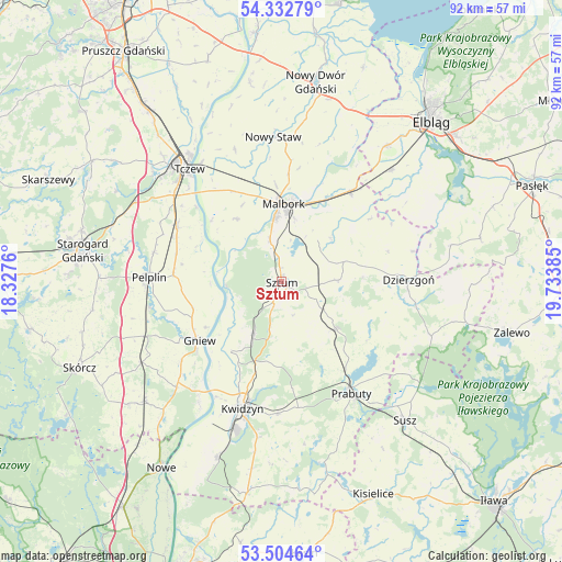
Sztum GPS coordinates[2]
53° 55' 14.772" North, 19° 1' 50.592" East
| Map corner | latitude | longitude |
|---|---|---|
| Upper-left | 54.33279°, | 18.3276° |
| Center: | 53.92077°, | 19.03072° |
| Lower-right: | 53.50464°, | 19.73385° |
| Map W x H: | 92.1×92.1 km | = 57.2×57.2mi |
| max Lat: | 54.83135° ⇑6.6% North |
| Sztum: | 53.92077° |
| min Lat: | ⇓93.4% South 49.21328° |
| min Long | Sztum | max Long |
| 14.20249° | 19.03072° | 24.03723° |
| W 40.5%⇐ | ⇒59.5% E |
Elevation
Elevation of Sztum is 58 m = 190 ft, and this is 133.4 m = 438 ft below average elevation for this country.
| Max E: |
974 m = 3196 ft | 93.3% |
| Avg. | 191.4 m = 628 ft | |
| Sztum | 58 m = 190 ft | |
Min E: |
-3 m = -10 ft | 6.7% |
See also: Poland elevation on elevation.city.
Geographical zone
Sztum is located in North temperate zone (between Tropic of Cancer and the Arctic Circle). Distance of this North polar circle is 1405.7 km =873.5 mi to North.| Distance of | km | miles | from Sztum |
|---|---|---|---|
| North Pole | 4011.6 | 2492.7 | to North |
| Arctic Circle | 1405.7 | 873.5 | to North |
| Tropic Cancer | 3389.5 | 2106.1 | to South |
| Equator | 5995.4 | 3725.4 | to South |


Nearby cities:
15 places around Sztum: (largest is in red/bold)
• Czarlin
22.9 km =14.2 mi,  309°
309°
• Dzierzgoń
20.7 km =12.9 mi,  89°
89°
• Gniew
16.6 km =10.3 mi,  235°
235°
• Kwidzyn
22.7 km =14.1 mi,  196°
196°
• Lichnowy
22.9 km =14.2 mi,  340°
340°
• Malbork
12.8 km =8 mi,  358°
358°
• Mikołajki Pomorskie
11.7 km =7.3 mi,  131°
131°
• Miłoradz
12.7 km =7.9 mi,  324°
324°
• Pelplin
21.8 km =13.5 mi,  272°
272°
• Prabuty
21.7 km =13.5 mi,  148°
148°
• Ryjewo
9.6 km =6 mi,  208°
208°
• Stare Pole
19.1 km =11.9 mi,  37°
37°
• Stary Targ
9.1 km =5.7 mi, 88°
• Subkowy
19.4 km =12.1 mi,  297°
297°
• Wielkie Walichnowy
11.7 km =7.3 mi, 267°
Sources, notices
• [Note1] Compared only with cities in Poland existing in our database
• [Src1] Map data: © OpenStreetMap contributors (CC-BY-SA)
• [Src2] Other city data from geonames.org with taken over terms of usage.
• [Src3] Geographical zone / Annual Mean Temperature by Robert A. Rohde @ Wikipedia
