Prabuty geodata
Prabuty (Pomerania) is a seat of a third-order administrative division; located in Poland in Europe/Warsaw (GMT+2) time zone. With population of 8,488 people, there are 495 cities with bigger population in this country. Compared to other cities in Poland, 91.8% of cities are located further ↓South; 55.9% of cities are located further →East and 82.2% of cities have higher elevation than Prabuty. Note1


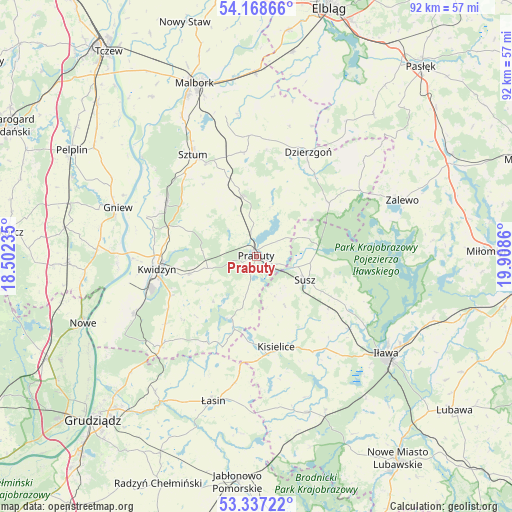
Prabuty GPS coordinates[2]
53° 45' 18" North, 19° 12' 19.692" East
| Map corner | latitude | longitude |
|---|---|---|
| Upper-left | 54.16866°, | 18.50235° |
| Center: | 53.755°, | 19.20547° |
| Lower-right: | 53.33722°, | 19.9086° |
| Map W x H: | 92.4×92.4 km | = 57.4×57.4mi |
| max Lat: | 54.83135° ⇑8.2% North |
| Prabuty: | 53.755° |
| min Lat: | ⇓91.8% South 49.21328° |
| min Long | Prabuty | max Long |
| 14.20249° | 19.20547° | 24.03723° |
| W 44.1%⇐ | ⇒55.9% E |
Elevation
Elevation of Prabuty is 95 m = 312 ft, and this is 96.4 m = 316 ft below average elevation for this country.
| Max E: |
974 m = 3196 ft | 82.2% |
| Avg. | 191.4 m = 628 ft | |
| Prabuty | 95 m = 312 ft | |
Min E: |
-3 m = -10 ft | 17.8% |
See also: Poland elevation on elevation.city.
Geographical zone
Prabuty is located in North temperate zone (between Tropic of Cancer and the Arctic Circle). Distance of this North polar circle is 1424.2 km =885 mi to North.| Distance of | km | miles | from Prabuty |
|---|---|---|---|
| North Pole | 4030.1 | 2504.2 | to North |
| Arctic Circle | 1424.2 | 885 | to North |
| Tropic Cancer | 3371.1 | 2094.7 | to South |
| Equator | 5977 | 3713.9 | to South |


Nearby cities:
15 places around Prabuty: (largest is in red/bold)
• Dzierzgoń
20.8 km =12.9 mi,  26°
26°
• Gardeja
23.4 km =14.5 mi,  226°
226°
• Gniew
26.7 km =16.6 mi,  289°
289°
• Iława
29.7 km =18.5 mi,  126°
126°
• Kisielice
16.7 km =10.4 mi,  166°
166°
• Kwidzyn
18.3 km =11.4 mi,  259°
259°
• Mikołajki Pomorskie
11 km =6.8 mi,  346°
346°
• Ryjewo
18.9 km =11.7 mi,  301°
301°
• Sadlinki
24.3 km =15.1 mi,  245°
245°
• Stary Targ
18.9 km =11.7 mi, 352°
• Susz
9.6 km =6 mi,  115°
115°
• Sztum
21.7 km =13.5 mi,  328°
328°
• Wielkie Walichnowy
29.3 km =18.2 mi,  307°
307°
• Zalewo
28.1 km =17.5 mi,  69°
69°
• Łasin
27.5 km =17.1 mi,  196°
196°
Sources, notices
• [Note1] Compared only with cities in Poland existing in our database
• [Src1] Map data: © OpenStreetMap contributors (CC-BY-SA)
• [Src2] Other city data from geonames.org with taken over terms of usage.
• [Src3] Geographical zone / Annual Mean Temperature by Robert A. Rohde @ Wikipedia
