Pniewy geodata
Pniewy (Greater Poland) is a seat of a third-order administrative division; located in Poland in Europe/Warsaw (GMT+2) time zone. With population of 7,738 people, there are 515 cities with bigger population in this country. Compared to other cities in Poland, 76.6% of cities are located further ↓South; 91% of cities are located further →East and 80.2% of cities have higher elevation than Pniewy. Note1


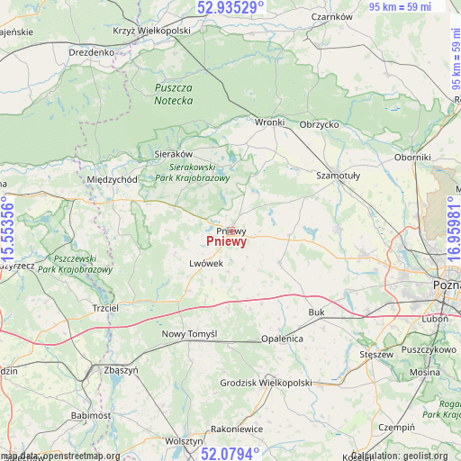
Pniewy GPS coordinates[2]
52° 30' 33.948" North, 16° 15' 24.048" East
| Map corner | latitude | longitude |
|---|---|---|
| Upper-left | 52.93529°, | 15.55356° |
| Center: | 52.50943°, | 16.25668° |
| Lower-right: | 52.0794°, | 16.95981° |
| Map W x H: | 95.2×95.2 km | = 59.2×59.2mi |
| max Lat: | 54.83135° ⇑23.4% North |
| Pniewy: | 52.50943° |
| min Lat: | ⇓76.6% South 49.21328° |
| min Long | Pniewy | max Long |
| 14.20249° | 16.25668° | 24.03723° |
| W 9%⇐ | ⇒91% E |
Elevation
Elevation of Pniewy is 99 m = 325 ft, and this is 92.4 m = 303 ft below average elevation for this country.
| Max E: |
974 m = 3196 ft | 80.2% |
| Avg. | 191.4 m = 628 ft | |
| Pniewy | 99 m = 325 ft | |
Min E: |
-3 m = -10 ft | 19.8% |
See also: Poland elevation on elevation.city.
Geographical zone
Pniewy is located in North temperate zone (between Tropic of Cancer and the Arctic Circle). Distance of this North polar circle is 1562.7 km =971 mi to North.| Distance of | km | miles | from Pniewy |
|---|---|---|---|
| North Pole | 4168.6 | 2590.2 | to North |
| Arctic Circle | 1562.7 | 971 | to North |
| Tropic Cancer | 3232.6 | 2008.6 | to South |
| Equator | 5838.5 | 3627.9 | to South |


Nearby cities:
15 places around Pniewy: (largest is in red/bold)
• Brody
8.3 km =5.2 mi,  161°
161°
• Chrzypsko Wielkie
13.3 km =8.3 mi,  351°
351°
• Duszniki
12.3 km =7.6 mi,  124°
124°
• Kaźmierz
22.2 km =13.8 mi,  88°
88°
• Kuślin
16.7 km =10.4 mi,  166°
166°
• Kwilcz
12.6 km =7.8 mi,  293°
293°
• Lipnica
16.6 km =10.3 mi,  65°
65°
• Lutom
15.1 km =9.4 mi,  329°
329°
• Lwówek
8.5 km =5.3 mi,  216°
216°
• Nowy Tomyśl
22.8 km =14.2 mi,  202°
202°
• Ostroróg
18.4 km =11.4 mi,  45°
45°
• Pakosław
8.3 km =5.2 mi,  184°
184°
• Sieraków
19.8 km =12.3 mi,  322°
322°
• Wronki
23.9 km =14.9 mi,  20°
20°
• Łowyń
23.6 km =14.7 mi,  267°
267°
Sources, notices
• [Note1] Compared only with cities in Poland existing in our database
• [Src1] Map data: © OpenStreetMap contributors (CC-BY-SA)
• [Src2] Other city data from geonames.org with taken over terms of usage.
• [Src3] Geographical zone / Annual Mean Temperature by Robert A. Rohde @ Wikipedia
