Lwówek geodata
Lwówek (Greater Poland) is a seat of a third-order administrative division; located in Poland in Europe/Warsaw (GMT+2) time zone. With population of 2,939 people, there are 1074 cities with bigger population in this country. Compared to other cities in Poland, 75.7% of cities are located further ↓South; 91.5% of cities are located further →East and 79.8% of cities have higher elevation than Lwówek. Note1


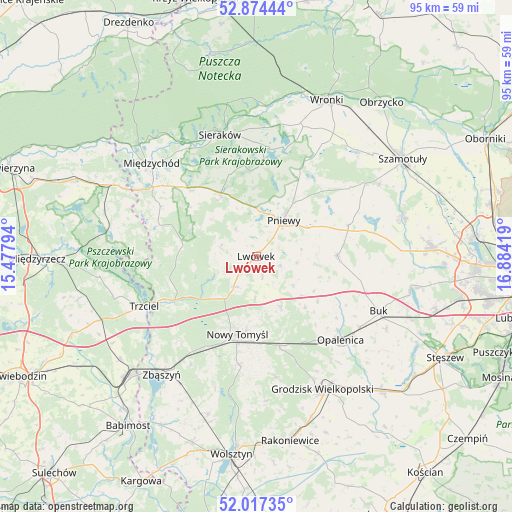
Lwówek GPS coordinates[2]
52° 26' 52.728" North, 16° 10' 51.816" East
| Map corner | latitude | longitude |
|---|---|---|
| Upper-left | 52.87444°, | 15.47794° |
| Center: | 52.44798°, | 16.18106° |
| Lower-right: | 52.01735°, | 16.88419° |
| Map W x H: | 95.3×95.3 km | = 59.2×59.2mi |
| max Lat: | 54.83135° ⇑24.3% North |
| Lwówek: | 52.44798° |
| min Lat: | ⇓75.7% South 49.21328° |
| min Long | Lwówek | max Long |
| 14.20249° | 16.18106° | 24.03723° |
| W 8.5%⇐ | ⇒91.5% E |
Elevation
Elevation of Lwówek is 100 m = 328 ft, and this is 91.4 m = 300 ft below average elevation for this country.
| Max E: |
974 m = 3196 ft | 79.8% |
| Avg. | 191.4 m = 628 ft | |
| Lwówek | 100 m = 328 ft | |
Min E: |
-3 m = -10 ft | 20.2% |
See also: Poland elevation on elevation.city.
Geographical zone
Lwówek is located in North temperate zone (between Tropic of Cancer and the Arctic Circle). Distance of this North polar circle is 1569.5 km =975.2 mi to North.| Distance of | km | miles | from Lwówek |
|---|---|---|---|
| North Pole | 4175.4 | 2594.5 | to North |
| Arctic Circle | 1569.5 | 975.2 | to North |
| Tropic Cancer | 3225.7 | 2004.4 | to South |
| Equator | 5831.7 | 3623.6 | to South |


Nearby cities:
15 places around Lwówek: (largest is in red/bold)
• Brody
7.8 km =4.8 mi,  97°
97°
• Chrzypsko Wielkie
20.3 km =12.6 mi,  9°
9°
• Duszniki
15.2 km =9.4 mi,  90°
90°
• Kuślin
13.1 km =8.1 mi,  135°
135°
• Kwilcz
13.5 km =8.4 mi,  331°
331°
• Lipnica
24.4 km =15.2 mi,  55°
55°
• Lutom
20 km =12.4 mi,  352°
352°
• Miedzichowo
17.1 km =10.6 mi,  241°
241°
• Nowy Tomyśl
14.7 km =9.1 mi,  194°
194°
• Opalenica
22.1 km =13.7 mi,  134°
134°
• Pakosław
4.7 km =2.9 mi,  108°
108°
• Pniewy
8.5 km =5.3 mi,  36°
36°
• Sieraków
23.6 km =14.7 mi,  343°
343°
• Trzciel
22.8 km =14.2 mi,  246°
246°
• Łowyń
19.4 km =12.1 mi,  287°
287°
Sources, notices
• [Note1] Compared only with cities in Poland existing in our database
• [Src1] Map data: © OpenStreetMap contributors (CC-BY-SA)
• [Src2] Other city data from geonames.org with taken over terms of usage.
• [Src3] Geographical zone / Annual Mean Temperature by Robert A. Rohde @ Wikipedia
