Dąbie geodata
Dąbie (Lubusz) is a seat of a third-order administrative division; located in Poland in Europe/Warsaw (GMT+2) time zone. With population of 417 people, there are 3580 cities with bigger population in this country. Compared to other cities in Poland, 65.8% of cities are located further ↓South; 97.1% of cities are located further →East and 88.9% of cities have higher elevation than Dąbie. Note1


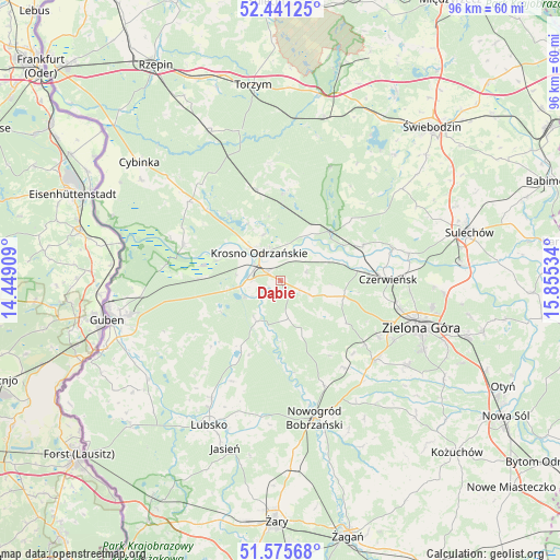
Dąbie GPS coordinates[2]
52° 0' 38.016" North, 15° 9' 7.956" East
| Map corner | latitude | longitude |
|---|---|---|
| Upper-left | 52.44125°, | 14.44909° |
| Center: | 52.01056°, | 15.15221° |
| Lower-right: | 51.57568°, | 15.85534° |
| Map W x H: | 96.2×96.2 km | = 59.8×59.8mi |
| max Lat: | 54.83135° ⇑34.2% North |
| Dąbie: | 52.01056° |
| min Lat: | ⇓65.8% South 49.21328° |
| min Long | Dąbie | max Long |
| 14.20249° | 15.15221° | 24.03723° |
| W 2.9%⇐ | ⇒97.1% E |
Elevation
Elevation of Dąbie is 79 m = 259 ft, and this is 112.4 m = 369 ft below average elevation for this country.
| Max E: |
974 m = 3196 ft | 88.9% |
| Avg. | 191.4 m = 628 ft | |
| Dąbie | 79 m = 259 ft | |
Min E: |
-3 m = -10 ft | 11.1% |
See also: Poland elevation on elevation.city.
Geographical zone
Dąbie is located in North temperate zone (between Tropic of Cancer and the Arctic Circle). Distance of this North polar circle is 1618.1 km =1005.4 mi to North.| Distance of | km | miles | from Dąbie |
|---|---|---|---|
| North Pole | 4224 | 2624.7 | to North |
| Arctic Circle | 1618.1 | 1005.4 | to North |
| Tropic Cancer | 3177.1 | 1974.2 | to South |
| Equator | 5783 | 3593.4 | to South |


Nearby cities:
15 places around Dąbie: (largest is in red/bold)
• Bobrowice
8.1 km =5 mi,  211°
211°
• Brody
20.1 km =12.5 mi,  73°
73°
• Bytnica
15.6 km =9.7 mi,  4°
4°
• Czerwieńsk
18.5 km =11.5 mi,  89°
89°
• Dychów
6.8 km =4.2 mi,  246°
246°
• Kaczeniec
24.3 km =15.1 mi,  147°
147°
• Krosno Odrzańskie
6.1 km =3.8 mi,  323°
323°
• Maszewo
18.1 km =11.2 mi,  291°
291°
• Międzylesie
21.7 km =13.5 mi,  46°
46°
• Nowogród Bobrzański
24.2 km =15 mi,  166°
166°
• Osiecznica
10.2 km =6.3 mi, 316°
• Ploty
18.1 km =11.2 mi,  98°
98°
• Skąpe
26.2 km =16.3 mi, 52°
• Zielona Góra
25.7 km =16 mi,  108°
108°
• Świdnica
21.2 km =13.2 mi,  129°
129°
Sources, notices
• [Note1] Compared only with cities in Poland existing in our database
• [Src1] Map data: © OpenStreetMap contributors (CC-BY-SA)
• [Src2] Other city data from geonames.org with taken over terms of usage.
• [Src3] Geographical zone / Annual Mean Temperature by Robert A. Rohde @ Wikipedia
