Rząśnia geodata
Rząśnia (Łódź Voivodeship) is a populated place; located in Poland in Europe/Warsaw (GMT+2) time zone. With population of 730 people, there are 3006 cities with bigger population in this country. Compared to other cities in Poland, 51.4% of cities are located further ↓South; 59.2% of cities are located further →East and 60.6% of cities have lower elevation than Rząśnia. Note1


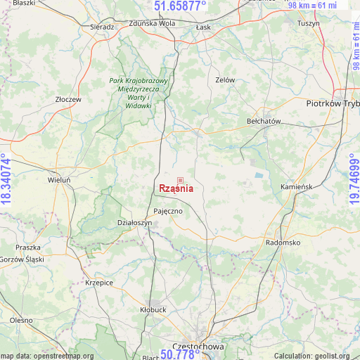
Rząśnia GPS coordinates[2]
51° 13' 13.764" North, 19° 2' 37.896" East
| Map corner | latitude | longitude |
|---|---|---|
| Upper-left | 51.65877°, | 18.34074° |
| Center: | 51.22049°, | 19.04386° |
| Lower-right: | 50.778°, | 19.74699° |
| Map W x H: | 97.9×97.9 km | = 60.8×60.8mi |
| max Lat: | 54.83135° ⇑48.6% North |
| Rząśnia: | 51.22049° |
| min Lat: | ⇓51.4% South 49.21328° |
| min Long | Rząśnia | max Long |
| 14.20249° | 19.04386° | 24.03723° |
| W 40.8%⇐ | ⇒59.2% E |
Elevation
Elevation of Rząśnia is 202 m = 663 ft, and this is 10.6 m = 35 ft above average elevation for this country.
| Max E: |
974 m = 3196 ft | 39.4% |
| Rząśnia | 202 m 663 ft | |
| Avg. | 191.4 m = 628 ft | |
Min E: |
-3 m = -10 ft | 60.6% |
See also: Poland elevation on elevation.city.
Geographical zone
Rząśnia is located in North temperate zone (between Tropic of Cancer and the Arctic Circle). Distance of this North polar circle is 1706 km =1060.1 mi to North.| Distance of | km | miles | from Rząśnia |
|---|---|---|---|
| North Pole | 4311.9 | 2679.3 | to North |
| Arctic Circle | 1706 | 1060.1 | to North |
| Tropic Cancer | 3089.3 | 1919.6 | to South |
| Equator | 5695.2 | 3538.8 | to South |


Nearby cities:
15 places around Rząśnia: (largest is in red/bold)
• Działoszyn
17 km =10.6 mi,  227°
227°
• Kiełczygłów
4.7 km =2.9 mi,  295°
295°
• Kleszczów
18.1 km =11.2 mi,  88°
88°
• Kluki
19.2 km =11.9 mi,  45°
45°
• Lgota Wielka
21.3 km =13.2 mi,  111°
111°
• Lipnik
12.3 km =7.6 mi,  276°
276°
• Nowa Brzeźnica
18.3 km =11.4 mi,  147°
147°
• Osjaków
19.2 km =11.9 mi,  293°
293°
• Pajęczno
9.1 km =5.7 mi,  201°
201°
• Rusiec
12.3 km =7.6 mi,  340°
340°
• Siemkowice
10.3 km =6.4 mi,  258°
258°
• Strzelce Wielkie
11.5 km =7.1 mi,  141°
141°
• Sulmierzyce
11.3 km =7 mi, 110°
• Szczerców
13.3 km =8.3 mi,  20°
20°
• Łękińsko
21.1 km =13.1 mi, 90°
Sources, notices
• [Note1] Compared only with cities in Poland existing in our database
• [Src1] Map data: © OpenStreetMap contributors (CC-BY-SA)
• [Src2] Other city data from geonames.org with taken over terms of usage.
• [Src3] Geographical zone / Annual Mean Temperature by Robert A. Rohde @ Wikipedia
