Chrzypsko Wielkie geodata
Chrzypsko Wielkie (Greater Poland) is a seat of a third-order administrative division; located in Poland in Europe/Warsaw (GMT+2) time zone. With population of 920 people, there are 2637 cities with bigger population in this country. Compared to other cities in Poland, 78.3% of cities are located further ↓South; 91.3% of cities are located further →East and 94% of cities have higher elevation than Chrzypsko Wielkie. Note1
Administrative division(s):
- Level 1: Greater Poland
- Level 2: Powiat międzychodzki
- Level 3: Chrzypsko Wielkie


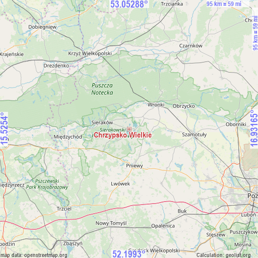
Chrzypsko Wielkie GPS coordinates[2]
52° 37' 41.412" North, 16° 13' 42.672" East
| Map corner | latitude | longitude |
|---|---|---|
| Upper-left | 53.05288°, | 15.5254° |
| Center: | 52.62817°, | 16.22852° |
| Lower-right: | 52.1993°, | 16.93165° |
| Map W x H: | 94.9×94.9 km | = 59×59mi |
| max Lat: | 54.83135° ⇑21.7% North |
| Chrzypsko Wielkie: | 52.62817° |
| min Lat: | ⇓78.3% South 49.21328° |
| min Long | Chrzypsko Wielk | max Long |
| 14.20249° | 16.22852° | 24.03723° |
| W 8.7%⇐ | ⇒91.3% E |
Elevation
Elevation of Chrzypsko Wielkie is 54 m = 177 ft, and this is 137.4 m = 451 ft below average elevation for this country.
| Max E: |
974 m = 3196 ft | 94% |
| Avg. | 191.4 m = 628 ft | |
| Chrzypsko Wielkie | 54 m = 177 ft | |
Min E: |
-3 m = -10 ft | 6% |
See also: Poland elevation on elevation.city.
Geographical zone
Chrzypsko Wielkie is located in North temperate zone (between Tropic of Cancer and the Arctic Circle). Distance of this North polar circle is 1549.5 km =962.8 mi to North.| Distance of | km | miles | from Chrzypsko Wielkie |
|---|---|---|---|
| North Pole | 4155.4 | 2582 | to North |
| Arctic Circle | 1549.5 | 962.8 | to North |
| Tropic Cancer | 3245.8 | 2016.8 | to South |
| Equator | 5851.7 | 3636.1 | to South |


Nearby cities:
15 places around Chrzypsko Wielkie: (largest is in red/bold)
• Brody
21.5 km =13.4 mi,  167°
167°
• Duszniki
23.5 km =14.6 mi,  149°
149°
• Kwilcz
12.6 km =7.8 mi,  229°
229°
• Lipnica
18.1 km =11.2 mi,  110°
110°
• Lutom
5.8 km =3.6 mi,  267°
267°
• Lwówek
20.3 km =12.6 mi,  189°
189°
• Międzychód
22.6 km =14 mi,  261°
261°
• Obrzycko
21.9 km =13.6 mi,  67°
67°
• Ostroróg
14.9 km =9.3 mi,  90°
90°
• Pakosław
21.5 km =13.4 mi,  176°
176°
• Pniewy
13.3 km =8.3 mi, 171°
• Sieraków
10.3 km =6.4 mi,  284°
284°
• Szamotuły
23.7 km =14.7 mi, 94°
• Wronki
13.7 km =8.5 mi,  48°
48°
• Łowyń
25.8 km =16 mi,  236°
236°
Sources, notices
• [Note1] Compared only with cities in Poland existing in our database
• [Src1] Map data: © OpenStreetMap contributors (CC-BY-SA)
• [Src2] Other city data from geonames.org with taken over terms of usage.
• [Src3] Geographical zone / Annual Mean Temperature by Robert A. Rohde @ Wikipedia
