Kłodawa geodata
Kłodawa (Greater Poland) is a seat of a third-order administrative division; located in Poland in Europe/Warsaw (GMT+2) time zone. With population of 6,714 people, there are 561 cities with bigger population in this country. Compared to other cities in Poland, 71.5% of cities are located further ↓South; 61.7% of cities are located further →East and 76.9% of cities have higher elevation than Kłodawa. Note1


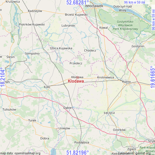
Kłodawa GPS coordinates[2]
52° 15' 16.092" North, 18° 54' 48.672" East
| Map corner | latitude | longitude |
|---|---|---|
| Upper-left | 52.68281°, | 18.2104° |
| Center: | 52.25447°, | 18.91352° |
| Lower-right: | 51.82196°, | 19.61665° |
| Map W x H: | 95.7×95.7 km | = 59.5×59.5mi |
| max Lat: | 54.83135° ⇑28.5% North |
| Kłodawa: | 52.25447° |
| min Lat: | ⇓71.5% South 49.21328° |
| min Long | Kłodawa | max Long |
| 14.20249° | 18.91352° | 24.03723° |
| W 38.3%⇐ | ⇒61.7% E |
Elevation
Elevation of Kłodawa is 106 m = 348 ft, and this is 85.4 m = 280 ft below average elevation for this country.
| Max E: |
974 m = 3196 ft | 76.9% |
| Avg. | 191.4 m = 628 ft | |
| Kłodawa | 106 m = 348 ft | |
Min E: |
-3 m = -10 ft | 23.1% |
See also: Poland elevation on elevation.city.
Geographical zone
Kłodawa is located in North temperate zone (between Tropic of Cancer and the Arctic Circle). Distance of this North polar circle is 1591 km =988.6 mi to North.| Distance of | km | miles | from Kłodawa |
|---|---|---|---|
| North Pole | 4196.9 | 2607.8 | to North |
| Arctic Circle | 1591 | 988.6 | to North |
| Tropic Cancer | 3204.2 | 1991 | to South |
| Equator | 5810.2 | 3610.3 | to South |


Nearby cities:
15 places around Kłodawa: (largest is in red/bold)
• Babiak
19.6 km =12.2 mi,  301°
301°
• Brdów
16.7 km =10.4 mi,  311°
311°
• Chodecz
18.5 km =11.5 mi,  24°
24°
• Chodów
6.7 km =4.2 mi,  94°
94°
• Dąbie
19.7 km =12.2 mi,  198°
198°
• Dąbrowice
13.2 km =8.2 mi,  61°
61°
• Grabów
15.4 km =9.6 mi,  156°
156°
• Grzegorzew
13.6 km =8.5 mi,  244°
244°
• Izbica Kujawska
21.1 km =13.1 mi,  331°
331°
• Koło
19.7 km =12.2 mi,  252°
252°
• Krośniewice
17.5 km =10.9 mi, 89°
• Nowe Ostrowy
19.7 km =12.2 mi,  74°
74°
• Olszówka
7.9 km =4.9 mi,  205°
205°
• Ostrowy
18 km =11.2 mi, 72°
• Przedecz
8.9 km =5.5 mi,  353°
353°
Sources, notices
• [Note1] Compared only with cities in Poland existing in our database
• [Src1] Map data: © OpenStreetMap contributors (CC-BY-SA)
• [Src2] Other city data from geonames.org with taken over terms of usage.
• [Src3] Geographical zone / Annual Mean Temperature by Robert A. Rohde @ Wikipedia
