Dzierżoniów geodata
Dzierżoniów (Lower Silesia) is a seat of a third-order administrative division; located in Poland in Europe/Warsaw (GMT+2) time zone. With population of 34,168 people, there are 152 cities with bigger population in this country. Compared to other cities in Poland, 62.1% of cities are located further ↑North; 88.5% of cities are located further →East and 82.5% of cities have lower elevation than Dzierżoniów. Note1
Administrative division(s):
- Level 1: Lower Silesia
- Level 2: Powiat dzierżoniowski
- Level 3: Dzierżoniów


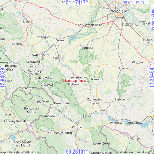
Dzierżoniów GPS coordinates[2]
50° 43' 41.52" North, 16° 39' 5.076" East
| Map corner | latitude | longitude |
|---|---|---|
| Upper-left | 51.17117°, | 15.94829° |
| Center: | 50.7282°, | 16.65141° |
| Lower-right: | 50.28101°, | 17.35454° |
| Map W x H: | 99×99 km | = 61.5×61.5mi |
| max Lat: | 54.83135° ⇑62.1% North |
| Dzierżoniów: | 50.7282° |
| min Lat: | ⇓37.9% South 49.21328° |
| min Long | Dzierżoniów | max Long |
| 14.20249° | 16.65141° | 24.03723° |
| W 11.5%⇐ | ⇒88.5% E |
Elevation
Elevation of Dzierżoniów is 278 m = 912 ft, and this is 86.6 m = 284 ft above average elevation for this country.
| Max E: |
974 m = 3196 ft | 17.5% |
| Dzierżoniów | 278 m 912 ft | |
| Avg. | 191.4 m = 628 ft | |
Min E: |
-3 m = -10 ft | 82.5% |
See also: Poland elevation on elevation.city.
Geographical zone
Dzierżoniów is located in North temperate zone (between Tropic of Cancer and the Arctic Circle). Distance of this North polar circle is 1760.7 km =1094 mi to North.| Distance of | km | miles | from Dzierżoniów |
|---|---|---|---|
| North Pole | 4366.6 | 2713.3 | to North |
| Arctic Circle | 1760.7 | 1094 | to North |
| Tropic Cancer | 3034.5 | 1885.6 | to South |
| Equator | 5640.4 | 3504.8 | to South |


Nearby cities:
15 places around Dzierżoniów: (largest is in red/bold)
• Bielawa
4.6 km =2.9 mi,  205°
205°
• Budzów
15.6 km =9.7 mi,  164°
164°
• Dobrocin
4 km =2.5 mi,  80°
80°
• Jodłownik
9.6 km =6 mi,  196°
196°
• Jugów
14.6 km =9.1 mi,  220°
220°
• Niemcza
13 km =8.1 mi,  93°
93°
• Ostroszowice
9.2 km =5.7 mi,  185°
185°
• Pieszyce
5.2 km =3.2 mi,  250°
250°
• Piława Górna
8.2 km =5.1 mi,  127°
127°
• Stoszowice
15.5 km =9.6 mi, 156°
• Uciechów
3.7 km =2.3 mi,  35°
35°
• Walim
14.9 km =9.3 mi,  256°
256°
• Wilków Wielki
14.2 km =8.8 mi, 78°
• Łagiewniki
15.3 km =9.5 mi,  62°
62°
• Świdnica
17.2 km =10.7 mi,  318°
318°
Sources, notices
• [Note1] Compared only with cities in Poland existing in our database
• [Src1] Map data: © OpenStreetMap contributors (CC-BY-SA)
• [Src2] Other city data from geonames.org with taken over terms of usage.
• [Src3] Geographical zone / Annual Mean Temperature by Robert A. Rohde @ Wikipedia
