Kiełczygłów geodata
Kiełczygłów (Łódź Voivodeship) is a populated place; located in Poland in Europe/Warsaw (GMT+2) time zone. With population of 561 people, there are 3375 cities with bigger population in this country. Compared to other cities in Poland, 51.8% of cities are located further ↓South; 60.3% of cities are located further →East and 51.2% of cities have lower elevation than Kiełczygłów. Note1
Administrative division(s):
- Level 1: Łódź Voivodeship
- Level 2: Powiat pajęczański
- Level 3: Kiełczygłów


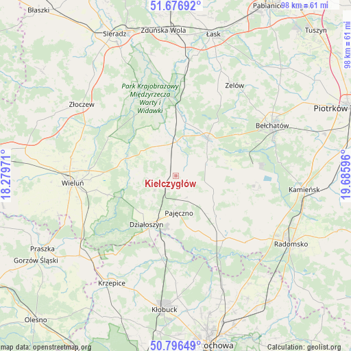
Kiełczygłów GPS coordinates[2]
51° 14' 19.716" North, 18° 58' 58.188" East
| Map corner | latitude | longitude |
|---|---|---|
| Upper-left | 51.67692°, | 18.27971° |
| Center: | 51.23881°, | 18.98283° |
| Lower-right: | 50.79649°, | 19.68596° |
| Map W x H: | 97.9×97.9 km | = 60.8×60.8mi |
| max Lat: | 54.83135° ⇑48.2% North |
| Kiełczygłów: | 51.23881° |
| min Lat: | ⇓51.8% South 49.21328° |
| min Long | Kiełczygłów | max Long |
| 14.20249° | 18.98283° | 24.03723° |
| W 39.7%⇐ | ⇒60.3% E |
Elevation
Elevation of Kiełczygłów is 175 m = 574 ft, and this is 16.4 m = 54 ft below average elevation for this country.
| Max E: |
974 m = 3196 ft | 48.8% |
| Avg. | 191.4 m = 628 ft | |
| Kiełczygłów | 175 m = 574 ft | |
Min E: |
-3 m = -10 ft | 51.2% |
See also: Poland elevation on elevation.city.
Geographical zone
Kiełczygłów is located in North temperate zone (between Tropic of Cancer and the Arctic Circle). Distance of this North polar circle is 1704 km =1058.8 mi to North.| Distance of | km | miles | from Kiełczygłów |
|---|---|---|---|
| North Pole | 4309.8 | 2678 | to North |
| Arctic Circle | 1704 | 1058.8 | to North |
| Tropic Cancer | 3091.3 | 1920.8 | to South |
| Equator | 5697.2 | 3540.1 | to South |


Nearby cities:
15 places around Kiełczygłów: (largest is in red/bold)
• Działoszyn
15.8 km =9.8 mi,  211°
211°
• Kleszczów
22.4 km =13.9 mi,  94°
94°
• Kluki
21.2 km =13.2 mi,  57°
57°
• Konopnica
16.9 km =10.5 mi,  319°
319°
• Lipnik
8 km =5 mi,  266°
266°
• Nowa Brzeźnica
22.4 km =13.9 mi,  141°
141°
• Osjaków
14.5 km =9 mi,  292°
292°
• Pajęczno
10.5 km =6.5 mi,  174°
174°
• Popów
22.4 km =13.9 mi,  189°
189°
• Rusiec
9.5 km =5.9 mi,  0°
0°
• Rząśnia
4.7 km =2.9 mi,  115°
115°
• Siemkowice
7.1 km =4.4 mi,  234°
234°
• Strzelce Wielkie
15.8 km =9.8 mi,  134°
134°
• Sulmierzyce
16 km =9.9 mi,  112°
112°
• Szczerców
13.7 km =8.5 mi,  40°
40°
Sources, notices
• [Note1] Compared only with cities in Poland existing in our database
• [Src1] Map data: © OpenStreetMap contributors (CC-BY-SA)
• [Src2] Other city data from geonames.org with taken over terms of usage.
• [Src3] Geographical zone / Annual Mean Temperature by Robert A. Rohde @ Wikipedia
