Drawsko geodata
Drawsko (Greater Poland) is a populated place; located in Poland in Europe/Warsaw (GMT+2) time zone. With population of 1,640 people, there are 1725 cities with bigger population in this country. Compared to other cities in Poland, 81.6% of cities are located further ↓South; 92.4% of cities are located further →East and 94.8% of cities have higher elevation than Drawsko. Note1
Administrative division(s):
- Level 1: Greater Poland
- Level 2: Powiat czarnkowsko-trzcianecki
- Level 3: Drawsko


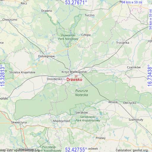
Drawsko GPS coordinates[2]
52° 51' 15.156" North, 16° 1' 52.5" East
| Map corner | latitude | longitude |
|---|---|---|
| Upper-left | 53.27671°, | 15.32813° |
| Center: | 52.85421°, | 16.03125° |
| Lower-right: | 52.42755°, | 16.73438° |
| Map W x H: | 94.4×94.4 km | = 58.7×58.7mi |
| max Lat: | 54.83135° ⇑18.4% North |
| Drawsko: | 52.85421° |
| min Lat: | ⇓81.6% South 49.21328° |
| min Long | Drawsko | max Long |
| 14.20249° | 16.03125° | 24.03723° |
| W 7.6%⇐ | ⇒92.4% E |
Elevation
Elevation of Drawsko is 45 m = 148 ft, and this is 146.4 m = 480 ft below average elevation for this country.
| Max E: |
974 m = 3196 ft | 94.8% |
| Avg. | 191.4 m = 628 ft | |
| Drawsko | 45 m = 148 ft | |
Min E: |
-3 m = -10 ft | 5.2% |
See also: Poland elevation on elevation.city.
Geographical zone
Drawsko is located in North temperate zone (between Tropic of Cancer and the Arctic Circle). Distance of this North polar circle is 1524.3 km =947.2 mi to North.| Distance of | km | miles | from Drawsko |
|---|---|---|---|
| North Pole | 4130.2 | 2566.4 | to North |
| Arctic Circle | 1524.3 | 947.2 | to North |
| Tropic Cancer | 3270.9 | 2032.4 | to South |
| Equator | 5876.8 | 3651.7 | to South |


Nearby cities:
15 places around Drawsko: (largest is in red/bold)
• Bierzwnik
31.8 km =19.8 mi,  309°
309°
• Chrzypsko Wielkie
28.4 km =17.6 mi,  152°
152°
• Człopa
26.7 km =16.6 mi,  12°
12°
• Dobiegniew
22.6 km =14 mi,  304°
304°
• Drezdenko
13.6 km =8.5 mi,  262°
262°
• Krzyż Wielkopolski
3.3 km =2.1 mi,  335°
335°
• Lubasz
33 km =20.5 mi,  90°
90°
• Lutom
26.4 km =16.4 mi,  163°
163°
• Międzychód
29.8 km =18.5 mi,  197°
197°
• Siedlisko
27.9 km =17.3 mi,  58°
58°
• Sieraków
22.8 km =14.2 mi,  171°
171°
• Stare Kurowo
23.8 km =14.8 mi,  270°
270°
• Wieleń
10.4 km =6.5 mi, 64°
• Wronki
28.4 km =17.6 mi,  124°
124°
• Zwierzyń
31.2 km =19.4 mi, 265°
Sources, notices
• [Note1] Compared only with cities in Poland existing in our database
• [Src1] Map data: © OpenStreetMap contributors (CC-BY-SA)
• [Src2] Other city data from geonames.org with taken over terms of usage.
• [Src3] Geographical zone / Annual Mean Temperature by Robert A. Rohde @ Wikipedia
