Wieleń geodata
Wieleń (Greater Poland) is a seat of a third-order administrative division; located in Poland in Europe/Warsaw (GMT+2) time zone. With population of 6,067 people, there are 598 cities with bigger population in this country. Compared to other cities in Poland, 82.3% of cities are located further ↓South; 91.6% of cities are located further →East and 95.6% of cities have higher elevation than Wieleń. Note1
Administrative division(s):
- Level 1: Greater Poland
- Level 2: Powiat czarnkowsko-trzcianecki
- Level 3: Wieleń


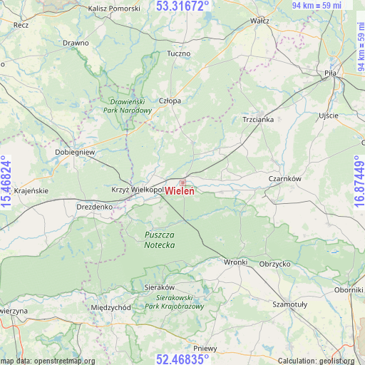
Wieleń GPS coordinates[2]
52° 53' 40.596" North, 16° 10' 16.896" East
| Map corner | latitude | longitude |
|---|---|---|
| Upper-left | 53.31672°, | 15.46824° |
| Center: | 52.89461°, | 16.17136° |
| Lower-right: | 52.46835°, | 16.87449° |
| Map W x H: | 94.3×94.3 km | = 58.6×58.6mi |
| max Lat: | 54.83135° ⇑17.7% North |
| Wieleń: | 52.89461° |
| min Lat: | ⇓82.3% South 49.21328° |
| min Long | Wieleń | max Long |
| 14.20249° | 16.17136° | 24.03723° |
| W 8.4%⇐ | ⇒91.6% E |
Elevation
Elevation of Wieleń is 35 m = 115 ft, and this is 156.4 m = 513 ft below average elevation for this country.
| Max E: |
974 m = 3196 ft | 95.6% |
| Avg. | 191.4 m = 628 ft | |
| Wieleń | 35 m = 115 ft | |
Min E: |
-3 m = -10 ft | 4.4% |
See also: Poland elevation on elevation.city.
Geographical zone
Wieleń is located in North temperate zone (between Tropic of Cancer and the Arctic Circle). Distance of this North polar circle is 1519.8 km =944.4 mi to North.| Distance of | km | miles | from Wieleń |
|---|---|---|---|
| North Pole | 4125.7 | 2563.6 | to North |
| Arctic Circle | 1519.8 | 944.4 | to North |
| Tropic Cancer | 3275.4 | 2035.2 | to South |
| Equator | 5881.3 | 3654.5 | to South |


Nearby cities:
15 places around Wieleń: (largest is in red/bold)
• Chrzypsko Wielkie
29.9 km =18.6 mi,  172°
172°
• Czarnków
26.4 km =16.4 mi,  88°
88°
• Człopa
21.8 km =13.5 mi,  351°
351°
• Dobiegniew
29.2 km =18.1 mi,  286°
286°
• Drawsko
10.4 km =6.5 mi,  244°
244°
• Drezdenko
23.7 km =14.7 mi,  254°
254°
• Krzyż Wielkopolski
10.9 km =6.8 mi,  261°
261°
• Lubasz
24.1 km =15 mi,  101°
101°
• Lutom
29.9 km =18.6 mi,  183°
183°
• Obrzycko
32 km =19.9 mi,  131°
131°
• Siedlisko
17.6 km =10.9 mi,  54°
54°
• Sieraków
27.7 km =17.2 mi,  192°
192°
• Trzcianka
25.1 km =15.6 mi, 49°
• Tuczno
33.3 km =20.7 mi,  357°
357°
• Wronki
24.8 km =15.4 mi,  145°
145°
Sources, notices
• [Note1] Compared only with cities in Poland existing in our database
• [Src1] Map data: © OpenStreetMap contributors (CC-BY-SA)
• [Src2] Other city data from geonames.org with taken over terms of usage.
• [Src3] Geographical zone / Annual Mean Temperature by Robert A. Rohde @ Wikipedia
