Człopa geodata
Człopa (West Pomerania) is a seat of a third-order administrative division; located in Poland in Europe/Warsaw (GMT+2) time zone. With population of 2,370 people, there are 1297 cities with bigger population in this country. Compared to other cities in Poland, 84.8% of cities are located further ↓South; 91.8% of cities are located further →East and 89.9% of cities have higher elevation than Człopa. Note1


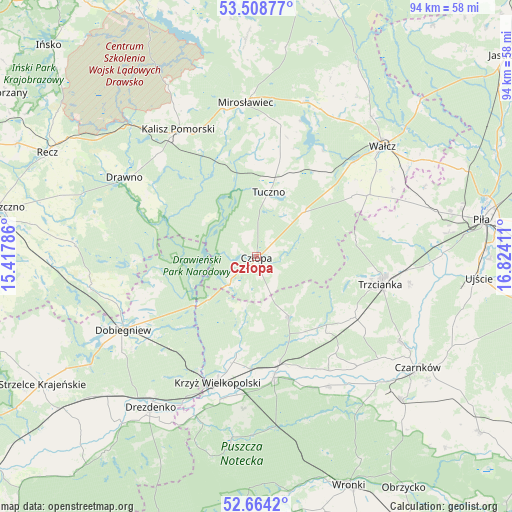
Człopa GPS coordinates[2]
53° 5' 18.816" North, 16° 7' 15.528" East
| Map corner | latitude | longitude |
|---|---|---|
| Upper-left | 53.50877°, | 15.41786° |
| Center: | 53.08856°, | 16.12098° |
| Lower-right: | 52.6642°, | 16.82411° |
| Map W x H: | 93.9×93.9 km | = 58.3×58.3mi |
| max Lat: | 54.83135° ⇑15.2% North |
| Człopa: | 53.08856° |
| min Lat: | ⇓84.8% South 49.21328° |
| min Long | Człopa | max Long |
| 14.20249° | 16.12098° | 24.03723° |
| W 8.2%⇐ | ⇒91.8% E |
Elevation
Elevation of Człopa is 76 m = 249 ft, and this is 115.4 m = 379 ft below average elevation for this country.
| Max E: |
974 m = 3196 ft | 89.9% |
| Avg. | 191.4 m = 628 ft | |
| Człopa | 76 m = 249 ft | |
Min E: |
-3 m = -10 ft | 10.1% |
See also: Poland elevation on elevation.city.
Geographical zone
Człopa is located in North temperate zone (between Tropic of Cancer and the Arctic Circle). Distance of this North polar circle is 1498.3 km =931 mi to North.| Distance of | km | miles | from Człopa |
|---|---|---|---|
| North Pole | 4104.2 | 2550.2 | to North |
| Arctic Circle | 1498.3 | 931 | to North |
| Tropic Cancer | 3297 | 2048.7 | to South |
| Equator | 5902.9 | 3667.9 | to South |


Nearby cities:
15 places around Człopa: (largest is in red/bold)
• Bierzwnik
31 km =19.3 mi,  259°
259°
• Dobiegniew
27.9 km =17.3 mi,  241°
241°
• Drawno
28.2 km =17.5 mi,  301°
301°
• Drawsko
26.7 km =16.6 mi,  192°
192°
• Drezdenko
33.9 km =21.1 mi,  214°
214°
• Kalisz Pomorski
27.4 km =17 mi,  328°
328°
• Krzyż Wielkopolski
24.2 km =15 mi,  197°
197°
• Mirosławiec
28.1 km =17.5 mi,  355°
355°
• Siedlisko
21 km =13 mi,  122°
122°
• Skrzatusz
33.3 km =20.7 mi,  67°
67°
• Szydłowo
33.7 km =20.9 mi,  75°
75°
• Trzcianka
23 km =14.3 mi,  103°
103°
• Tuczno
11.9 km =7.4 mi,  10°
10°
• Wałcz
31.4 km =19.5 mi,  47°
47°
• Wieleń
21.8 km =13.5 mi,  171°
171°
Sources, notices
• [Note1] Compared only with cities in Poland existing in our database
• [Src1] Map data: © OpenStreetMap contributors (CC-BY-SA)
• [Src2] Other city data from geonames.org with taken over terms of usage.
• [Src3] Geographical zone / Annual Mean Temperature by Robert A. Rohde @ Wikipedia
