Człuchów geodata
Człuchów (Pomerania) is a populated place; located in Poland in Europe/Warsaw (GMT+2) time zone. With population of 14,759 people, there are 341 cities with bigger population in this country. Compared to other cities in Poland, 91.2% of cities are located further ↓South; 81% of cities are located further →East and 52.9% of cities have higher elevation than Człuchów. Note1


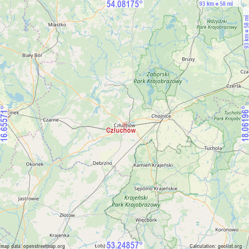
Człuchów GPS coordinates[2]
53° 40' 1.992" North, 17° 21' 31.788" East
| Map corner | latitude | longitude |
|---|---|---|
| Upper-left | 54.08175°, | 16.65571° |
| Center: | 53.66722°, | 17.35883° |
| Lower-right: | 53.24857°, | 18.06196° |
| Map W x H: | 92.6×92.6 km | = 57.5×57.5mi |
| max Lat: | 54.83135° ⇑8.8% North |
| Człuchów: | 53.66722° |
| min Lat: | ⇓91.2% South 49.21328° |
| min Long | Człuchów | max Long |
| 14.20249° | 17.35883° | 24.03723° |
| W 19%⇐ | ⇒81% E |
Elevation
Elevation of Człuchów is 164 m = 538 ft, and this is 27.4 m = 90 ft below average elevation for this country.
| Max E: |
974 m = 3196 ft | 52.9% |
| Avg. | 191.4 m = 628 ft | |
| Człuchów | 164 m = 538 ft | |
Min E: |
-3 m = -10 ft | 47.1% |
See also: Poland elevation on elevation.city.
Geographical zone
Człuchów is located in North temperate zone (between Tropic of Cancer and the Arctic Circle). Distance of this North polar circle is 1433.9 km =891 mi to North.| Distance of | km | miles | from Człuchów |
|---|---|---|---|
| North Pole | 4039.8 | 2510.2 | to North |
| Arctic Circle | 1433.9 | 891 | to North |
| Tropic Cancer | 3361.3 | 2088.6 | to South |
| Equator | 5967.2 | 3707.8 | to South |


Nearby cities:
15 places around Człuchów: (largest is in red/bold)
• Chojnice
13.4 km =8.3 mi,  76°
76°
• Czarne
27.8 km =17.3 mi,  273°
273°
• Debrzno
16.5 km =10.3 mi,  209°
209°
• Kamień Krajeński
18.3 km =11.4 mi,  144°
144°
• Koczała
32.7 km =20.3 mi,  323°
323°
• Konarzyny
17.4 km =10.8 mi,  4°
4°
• Kęsowo
26.5 km =16.5 mi,  117°
117°
• Lipka
20.3 km =12.6 mi,  200°
200°
• Lędyczek
29.9 km =18.6 mi,  240°
240°
• Ostrowite
20.7 km =12.9 mi,  100°
100°
• Przechlewo
16.2 km =10.1 mi,  334°
334°
• Raciąż
28.2 km =17.5 mi,  91°
91°
• Rzeczenica
19.4 km =12.1 mi,  301°
301°
• Sępólno Krajeńskie
26.5 km =16.5 mi,  154°
154°
• Zakrzewo
31.4 km =19.5 mi, 205°
Sources, notices
• [Note1] Compared only with cities in Poland existing in our database
• [Src1] Map data: © OpenStreetMap contributors (CC-BY-SA)
• [Src2] Other city data from geonames.org with taken over terms of usage.
• [Src3] Geographical zone / Annual Mean Temperature by Robert A. Rohde @ Wikipedia
