Ostrowite geodata
Ostrowite (Pomerania) is a populated place; located in Poland in Europe/Warsaw (GMT+2) time zone. With population of 526 people, there are 3466 cities with bigger population in this country. Compared to other cities in Poland, 90.8% of cities are located further ↓South; 78.6% of cities are located further →East and 64.1% of cities have higher elevation than Ostrowite. Note1


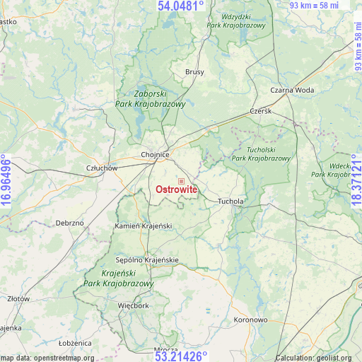
Ostrowite GPS coordinates[2]
53° 37' 59.664" North, 17° 40' 5.088" East
| Map corner | latitude | longitude |
|---|---|---|
| Upper-left | 54.0481°, | 16.96496° |
| Center: | 53.63324°, | 17.66808° |
| Lower-right: | 53.21426°, | 18.37121° |
| Map W x H: | 92.7×92.7 km | = 57.6×57.6mi |
| max Lat: | 54.83135° ⇑9.2% North |
| Ostrowite: | 53.63324° |
| min Lat: | ⇓90.8% South 49.21328° |
| min Long | Ostrowite | max Long |
| 14.20249° | 17.66808° | 24.03723° |
| W 21.4%⇐ | ⇒78.6% E |
Elevation
Elevation of Ostrowite is 136 m = 446 ft, and this is 55.4 m = 182 ft below average elevation for this country.
| Max E: |
974 m = 3196 ft | 64.1% |
| Avg. | 191.4 m = 628 ft | |
| Ostrowite | 136 m = 446 ft | |
Min E: |
-3 m = -10 ft | 35.9% |
See also: Poland elevation on elevation.city.
Geographical zone
Ostrowite is located in North temperate zone (between Tropic of Cancer and the Arctic Circle). Distance of this North polar circle is 1437.7 km =893.3 mi to North.| Distance of | km | miles | from Ostrowite |
|---|---|---|---|
| North Pole | 4043.6 | 2512.6 | to North |
| Arctic Circle | 1437.7 | 893.3 | to North |
| Tropic Cancer | 3357.5 | 2086.3 | to South |
| Equator | 5963.5 | 3705.5 | to South |


Nearby cities:
15 places around Ostrowite: (largest is in red/bold)
• Brusy
28.1 km =17.5 mi,  6°
6°
• Cekcyn
23.6 km =14.7 mi,  106°
106°
• Chojnice
10.1 km =6.3 mi,  313°
313°
• Czersk
27.2 km =16.9 mi,  48°
48°
• Człuchów
20.7 km =12.9 mi,  280°
280°
• Gostycyn
18.5 km =11.5 mi,  149°
149°
• Kamienica
19.6 km =12.2 mi, 151°
• Kamień Krajeński
14.8 km =9.2 mi,  221°
221°
• Konarzyny
28.4 km =17.6 mi,  318°
318°
• Kęsowo
8.9 km =5.5 mi,  159°
159°
• Lubiewo
30.3 km =18.8 mi,  127°
127°
• Raciąż
8.5 km =5.3 mi,  67°
67°
• Sośno
27.2 km =16.9 mi,  177°
177°
• Sępólno Krajeńskie
22.1 km =13.7 mi,  204°
204°
• Tuchola
13.6 km =8.5 mi, 111°
Sources, notices
• [Note1] Compared only with cities in Poland existing in our database
• [Src1] Map data: © OpenStreetMap contributors (CC-BY-SA)
• [Src2] Other city data from geonames.org with taken over terms of usage.
• [Src3] Geographical zone / Annual Mean Temperature by Robert A. Rohde @ Wikipedia
