Przechlewo geodata
Przechlewo (Pomerania) is a populated place; located in Poland in Europe/Warsaw (GMT+2) time zone. With population of 2,826 people, there are 1110 cities with bigger population in this country. Compared to other cities in Poland, 92.3% of cities are located further ↓South; 81.8% of cities are located further →East and 58.7% of cities have higher elevation than Przechlewo. Note1


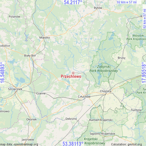
Przechlewo GPS coordinates[2]
53° 47' 54.492" North, 17° 15' 7.38" East
| Map corner | latitude | longitude |
|---|---|---|
| Upper-left | 54.2117°, | 16.54893° |
| Center: | 53.79847°, | 17.25205° |
| Lower-right: | 53.38113°, | 17.95518° |
| Map W x H: | 92.4×92.3 km | = 57.4×57.4mi |
| max Lat: | 54.83135° ⇑7.7% North |
| Przechlewo: | 53.79847° |
| min Lat: | ⇓92.3% South 49.21328° |
| min Long | Przechlewo | max Long |
| 14.20249° | 17.25205° | 24.03723° |
| W 18.2%⇐ | ⇒81.8% E |
Elevation
Elevation of Przechlewo is 149 m = 489 ft, and this is 42.4 m = 139 ft below average elevation for this country.
| Max E: |
974 m = 3196 ft | 58.7% |
| Avg. | 191.4 m = 628 ft | |
| Przechlewo | 149 m = 489 ft | |
Min E: |
-3 m = -10 ft | 41.3% |
See also: Poland elevation on elevation.city.
Geographical zone
Przechlewo is located in North temperate zone (between Tropic of Cancer and the Arctic Circle). Distance of this North polar circle is 1419.3 km =881.9 mi to North.| Distance of | km | miles | from Przechlewo |
|---|---|---|---|
| North Pole | 4025.2 | 2501.1 | to North |
| Arctic Circle | 1419.3 | 881.9 | to North |
| Tropic Cancer | 3375.9 | 2097.7 | to South |
| Equator | 5981.8 | 3716.9 | to South |


Nearby cities:
15 places around Przechlewo: (largest is in red/bold)
• Biały Bór
29.4 km =18.3 mi,  291°
291°
• Brusy
32 km =19.9 mi,  72°
72°
• Chojnice
23.1 km =14.4 mi,  119°
119°
• Czarne
24.2 km =15 mi,  238°
238°
• Człuchów
16.2 km =10.1 mi,  154°
154°
• Debrzno
29 km =18 mi,  182°
182°
• Kamień Krajeński
34.3 km =21.3 mi, 149°
• Koczała
17 km =10.6 mi,  313°
313°
• Konarzyny
8.8 km =5.5 mi, 71°
• Lipka
33.6 km =20.9 mi, 180°
• Lipnica
24.2 km =15 mi,  24°
24°
• Miastko
28.8 km =17.9 mi,  322°
322°
• Ostrowite
33 km =20.5 mi, 123°
• Rzeczenica
10.5 km =6.5 mi, 244°
• Żółtnica
32.2 km =20 mi, 244°
Sources, notices
• [Note1] Compared only with cities in Poland existing in our database
• [Src1] Map data: © OpenStreetMap contributors (CC-BY-SA)
• [Src2] Other city data from geonames.org with taken over terms of usage.
• [Src3] Geographical zone / Annual Mean Temperature by Robert A. Rohde @ Wikipedia
