Konarzyny geodata
Konarzyny (Pomerania) is a populated place; located in Poland in Europe/Warsaw (GMT+2) time zone. With population of 523 people, there are 3473 cities with bigger population in this country. Compared to other cities in Poland, 92.4% of cities are located further ↓South; 80.8% of cities are located further →East and 58.7% of cities have higher elevation than Konarzyny. Note1


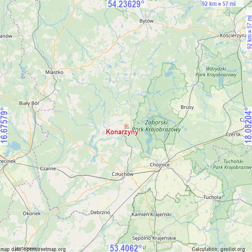
Konarzyny GPS coordinates[2]
53° 49' 23.88" North, 17° 22' 44.076" East
| Map corner | latitude | longitude |
|---|---|---|
| Upper-left | 54.23629°, | 16.67579° |
| Center: | 53.8233°, | 17.37891° |
| Lower-right: | 53.4062°, | 18.08204° |
| Map W x H: | 92.3×92.3 km | = 57.4×57.4mi |
| max Lat: | 54.83135° ⇑7.6% North |
| Konarzyny: | 53.8233° |
| min Lat: | ⇓92.4% South 49.21328° |
| min Long | Konarzyny | max Long |
| 14.20249° | 17.37891° | 24.03723° |
| W 19.2%⇐ | ⇒80.8% E |
Elevation
Elevation of Konarzyny is 149 m = 489 ft, and this is 42.4 m = 139 ft below average elevation for this country.
| Max E: |
974 m = 3196 ft | 58.7% |
| Avg. | 191.4 m = 628 ft | |
| Konarzyny | 149 m = 489 ft | |
Min E: |
-3 m = -10 ft | 41.3% |
See also: Poland elevation on elevation.city.
Geographical zone
Konarzyny is located in North temperate zone (between Tropic of Cancer and the Arctic Circle). Distance of this North polar circle is 1416.6 km =880.2 mi to North.| Distance of | km | miles | from Konarzyny |
|---|---|---|---|
| North Pole | 4022.5 | 2499.5 | to North |
| Arctic Circle | 1416.6 | 880.2 | to North |
| Tropic Cancer | 3378.7 | 2099.4 | to South |
| Equator | 5984.6 | 3718.7 | to South |


Nearby cities:
15 places around Konarzyny: (largest is in red/bold)
• Brusy
23.2 km =14.4 mi,  72°
72°
• Chojnice
18.4 km =11.4 mi,  140°
140°
• Czarne
32.8 km =20.4 mi,  241°
241°
• Człuchów
17.4 km =10.8 mi,  184°
184°
• Debrzno
33.1 km =20.6 mi,  196°
196°
• Dziemiany
32.6 km =20.3 mi,  51°
51°
• Koczała
22.5 km =14 mi,  293°
293°
• Lipnica
19.3 km =12 mi,  5°
5°
• Miastko
32.7 km =20.3 mi,  307°
307°
• Ostrowite
28.4 km =17.6 mi, 138°
• Przechlewo
8.8 km =5.5 mi,  251°
251°
• Raciąż
32.3 km =20.1 mi,  123°
123°
• Rzeczenica
19.3 km =12 mi, 247°
• Studzienice
32.6 km =20.3 mi,  23°
23°
• Tuchomie
32.6 km =20.3 mi,  355°
355°
Sources, notices
• [Note1] Compared only with cities in Poland existing in our database
• [Src1] Map data: © OpenStreetMap contributors (CC-BY-SA)
• [Src2] Other city data from geonames.org with taken over terms of usage.
• [Src3] Geographical zone / Annual Mean Temperature by Robert A. Rohde @ Wikipedia
