Chojnice geodata
Chojnice (Pomerania) is a populated place; located in Poland in Europe/Warsaw (GMT+2) time zone. With population of 39,407 people, there are 131 cities with bigger population in this country. Compared to other cities in Poland, 91.3% of cities are located further ↓South; 79.4% of cities are located further →East and 57.6% of cities have higher elevation than Chojnice. Note1


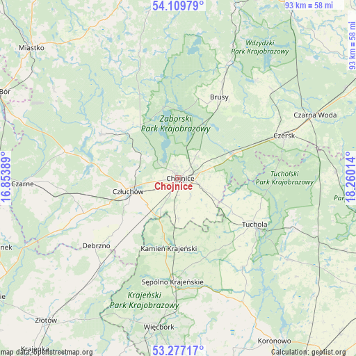
Chojnice GPS coordinates[2]
53° 41' 43.944" North, 17° 33' 25.236" East
| Map corner | latitude | longitude |
|---|---|---|
| Upper-left | 54.10979°, | 16.85389° |
| Center: | 53.69554°, | 17.55701° |
| Lower-right: | 53.27717°, | 18.26014° |
| Map W x H: | 92.6×92.6 km | = 57.5×57.5mi |
| max Lat: | 54.83135° ⇑8.7% North |
| Chojnice: | 53.69554° |
| min Lat: | ⇓91.3% South 49.21328° |
| min Long | Chojnice | max Long |
| 14.20249° | 17.55701° | 24.03723° |
| W 20.6%⇐ | ⇒79.4% E |
Elevation
Elevation of Chojnice is 152 m = 499 ft, and this is 39.4 m = 129 ft below average elevation for this country.
| Max E: |
974 m = 3196 ft | 57.6% |
| Avg. | 191.4 m = 628 ft | |
| Chojnice | 152 m = 499 ft | |
Min E: |
-3 m = -10 ft | 42.4% |
See also: Poland elevation on elevation.city.
Geographical zone
Chojnice is located in North temperate zone (between Tropic of Cancer and the Arctic Circle). Distance of this North polar circle is 1430.8 km =889.1 mi to North.| Distance of | km | miles | from Chojnice |
|---|---|---|---|
| North Pole | 4036.7 | 2508.3 | to North |
| Arctic Circle | 1430.8 | 889.1 | to North |
| Tropic Cancer | 3364.5 | 2090.6 | to South |
| Equator | 5970.4 | 3709.8 | to South |


Nearby cities:
15 places around Chojnice: (largest is in red/bold)
• Brusy
23.5 km =14.6 mi,  26°
26°
• Czersk
29.8 km =18.5 mi,  67°
67°
• Człuchów
13.4 km =8.3 mi,  256°
256°
• Debrzno
27.4 km =17 mi,  230°
230°
• Gostycyn
28.3 km =17.6 mi,  143°
143°
• Kamienica
29.3 km =18.2 mi,  145°
145°
• Kamień Krajeński
18.2 km =11.3 mi,  187°
187°
• Konarzyny
18.4 km =11.4 mi,  320°
320°
• Kęsowo
18.5 km =11.5 mi, 145°
• Lipka
30 km =18.6 mi,  222°
222°
• Ostrowite
10.1 km =6.3 mi,  133°
133°
• Przechlewo
23.1 km =14.4 mi,  299°
299°
• Raciąż
15.6 km =9.7 mi,  103°
103°
• Sępólno Krajeńskie
27.1 km =16.8 mi,  183°
183°
• Tuchola
23.2 km =14.4 mi,  121°
121°
Sources, notices
• [Note1] Compared only with cities in Poland existing in our database
• [Src1] Map data: © OpenStreetMap contributors (CC-BY-SA)
• [Src2] Other city data from geonames.org with taken over terms of usage.
• [Src3] Geographical zone / Annual Mean Temperature by Robert A. Rohde @ Wikipedia
