Rzeczenica geodata
Rzeczenica (Pomerania) is a populated place; located in Poland in Europe/Warsaw (GMT+2) time zone. With population of 1,566 people, there are 1793 cities with bigger population in this country. Compared to other cities in Poland, 91.9% of cities are located further ↓South; 83.1% of cities are located further →East and 58.4% of cities have higher elevation than Rzeczenica. Note1


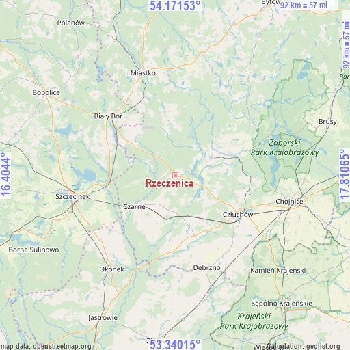
Rzeczenica GPS coordinates[2]
53° 45' 28.44" North, 17° 6' 27.072" East
| Map corner | latitude | longitude |
|---|---|---|
| Upper-left | 54.17153°, | 16.4044° |
| Center: | 53.7579°, | 17.10752° |
| Lower-right: | 53.34015°, | 17.81065° |
| Map W x H: | 92.4×92.4 km | = 57.4×57.4mi |
| max Lat: | 54.83135° ⇑8.1% North |
| Rzeczenica: | 53.7579° |
| min Lat: | ⇓91.9% South 49.21328° |
| min Long | Rzeczenica | max Long |
| 14.20249° | 17.10752° | 24.03723° |
| W 16.9%⇐ | ⇒83.1% E |
Elevation
Elevation of Rzeczenica is 150 m = 492 ft, and this is 41.4 m = 136 ft below average elevation for this country.
| Max E: |
974 m = 3196 ft | 58.4% |
| Avg. | 191.4 m = 628 ft | |
| Rzeczenica | 150 m = 492 ft | |
Min E: |
-3 m = -10 ft | 41.6% |
See also: Poland elevation on elevation.city.
Geographical zone
Rzeczenica is located in North temperate zone (between Tropic of Cancer and the Arctic Circle). Distance of this North polar circle is 1423.9 km =884.8 mi to North.| Distance of | km | miles | from Rzeczenica |
|---|---|---|---|
| North Pole | 4029.7 | 2503.9 | to North |
| Arctic Circle | 1423.9 | 884.8 | to North |
| Tropic Cancer | 3371.4 | 2094.9 | to South |
| Equator | 5977.3 | 3714.1 | to South |


Nearby cities:
15 places around Rzeczenica: (largest is in red/bold)
• Biały Bór
23.6 km =14.7 mi,  310°
310°
• Chojnice
30.4 km =18.9 mi,  103°
103°
• Czarne
13.8 km =8.6 mi,  233°
233°
• Człuchów
19.4 km =12.1 mi,  121°
121°
• Debrzno
25.9 km =16.1 mi,  160°
160°
• Koczała
16.5 km =10.3 mi,  350°
350°
• Konarzyny
19.3 km =12 mi,  67°
67°
• Lipka
30.6 km =19 mi, 162°
• Lędyczek
26.4 km =16.4 mi,  201°
201°
• Miastko
28.4 km =17.6 mi,  343°
343°
• Okonek
29.9 km =18.6 mi,  214°
214°
• Przechlewo
10.5 km =6.5 mi,  64°
64°
• Sitno
31.1 km =19.3 mi,  249°
249°
• Szczecinek
27.4 km =17 mi,  258°
258°
• Żółtnica
21.7 km =13.5 mi,  244°
244°
Sources, notices
• [Note1] Compared only with cities in Poland existing in our database
• [Src1] Map data: © OpenStreetMap contributors (CC-BY-SA)
• [Src2] Other city data from geonames.org with taken over terms of usage.
• [Src3] Geographical zone / Annual Mean Temperature by Robert A. Rohde @ Wikipedia
