Orneta geodata
Orneta (Warmia-Masuria) is a seat of a third-order administrative division; located in Poland in Europe/Warsaw (GMT+2) time zone. With population of 9,412 people, there are 462 cities with bigger population in this country. Compared to other cities in Poland, 95.4% of cities are located further ↓South; 60.6% of cities are located further ←West and 93.1% of cities have higher elevation than Orneta. Note1


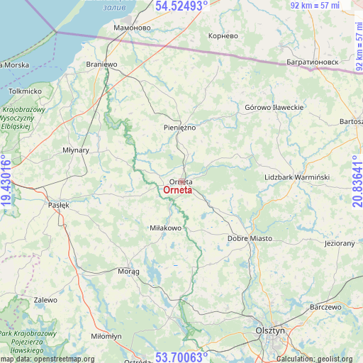
Orneta GPS coordinates[2]
54° 6' 53.388" North, 20° 7' 59.808" East
| Map corner | latitude | longitude |
|---|---|---|
| Upper-left | 54.52493°, | 19.43016° |
| Center: | 54.11483°, | 20.13328° |
| Lower-right: | 53.70063°, | 20.83641° |
| Map W x H: | 91.7×91.7 km | = 57×57mi |
| max Lat: | 54.83135° ⇑4.6% North |
| Orneta: | 54.11483° |
| min Lat: | ⇓95.4% South 49.21328° |
| min Long | Orneta | max Long |
| 14.20249° | 20.13328° | 24.03723° |
| W 60.6%⇐ | ⇒39.4% E |
Elevation
Elevation of Orneta is 59 m = 194 ft, and this is 132.4 m = 434 ft below average elevation for this country.
| Max E: |
974 m = 3196 ft | 93.1% |
| Avg. | 191.4 m = 628 ft | |
| Orneta | 59 m = 194 ft | |
Min E: |
-3 m = -10 ft | 6.9% |
See also: Poland elevation on elevation.city.
Geographical zone
Orneta is located in North temperate zone (between Tropic of Cancer and the Arctic Circle). Distance of this North polar circle is 1384.2 km =860.1 mi to North.| Distance of | km | miles | from Orneta |
|---|---|---|---|
| North Pole | 3990.1 | 2479.3 | to North |
| Arctic Circle | 1384.2 | 860.1 | to North |
| Tropic Cancer | 3411.1 | 2119.6 | to South |
| Equator | 6017 | 3738.8 | to South |


Nearby cities:
15 places around Orneta: (largest is in red/bold)
• Dobre Miasto
22.4 km =13.9 mi,  129°
129°
• Górowo Iławeckie
29.9 km =18.6 mi,  50°
50°
• Janikowo
24.4 km =15.2 mi,  60°
60°
• Jonkowo
33.9 km =21.1 mi,  160°
160°
• Lelkowo
24.1 km =15 mi,  14°
14°
• Lidzbark Warmiński
29.1 km =18.1 mi,  87°
87°
• Lubomino
8.7 km =5.4 mi, 127°
• Małdyty
33.4 km =20.8 mi,  229°
229°
• Miłakowo
12.4 km =7.7 mi,  199°
199°
• Morąg
25.8 km =16 mi,  211°
211°
• Młynary
28 km =17.4 mi,  286°
286°
• Pasłęk
31.5 km =19.6 mi,  259°
259°
• Pieniężno
13.5 km =8.4 mi,  358°
358°
• Spręcowo
32.8 km =20.4 mi,  142°
142°
• Świątki
22.1 km =13.7 mi, 161°
Sources, notices
• [Note1] Compared only with cities in Poland existing in our database
• [Src1] Map data: © OpenStreetMap contributors (CC-BY-SA)
• [Src2] Other city data from geonames.org with taken over terms of usage.
• [Src3] Geographical zone / Annual Mean Temperature by Robert A. Rohde @ Wikipedia
