Żółtnica geodata
Żółtnica (West Pomerania) is a populated place; located in Poland in Europe/Warsaw (GMT+2) time zone. With population of 590 people, there are 3306 cities with bigger population in this country. Compared to other cities in Poland, 91.2% of cities are located further ↓South; 87.3% of cities are located further →East and 59.9% of cities have higher elevation than Żółtnica. Note1
Administrative division(s):
- Level 1: West Pomerania
- Level 2: Powiat szczecinecki
- Level 3: Szczecinek


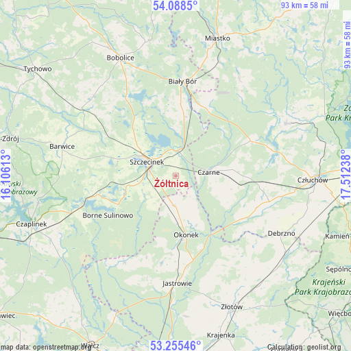
Żółtnica GPS coordinates[2]
53° 40' 26.544" North, 16° 48' 33.3" East
| Map corner | latitude | longitude |
|---|---|---|
| Upper-left | 54.0885°, | 16.10613° |
| Center: | 53.67404°, | 16.80925° |
| Lower-right: | 53.25546°, | 17.51238° |
| Map W x H: | 92.6×92.6 km | = 57.5×57.5mi |
| max Lat: | 54.83135° ⇑8.8% North |
| Żółtnica: | 53.67404° |
| min Lat: | ⇓91.2% South 49.21328° |
| min Long | Żółtnica | max Long |
| 14.20249° | 16.80925° | 24.03723° |
| W 12.7%⇐ | ⇒87.3% E |
Elevation
Elevation of Żółtnica is 147 m = 482 ft, and this is 44.4 m = 146 ft below average elevation for this country.
| Max E: |
974 m = 3196 ft | 59.9% |
| Avg. | 191.4 m = 628 ft | |
| Żółtnica | 147 m = 482 ft | |
Min E: |
-3 m = -10 ft | 40.1% |
See also: Poland elevation on elevation.city.
Geographical zone
Żółtnica is located in North temperate zone (between Tropic of Cancer and the Arctic Circle). Distance of this North polar circle is 1433.2 km =890.5 mi to North.| Distance of | km | miles | from Żółtnica |
|---|---|---|---|
| North Pole | 4039.1 | 2509.8 | to North |
| Arctic Circle | 1433.2 | 890.5 | to North |
| Tropic Cancer | 3362.1 | 2089.1 | to South |
| Equator | 5968 | 3708.3 | to South |


Nearby cities:
15 places around Żółtnica: (largest is in red/bold)
• Barwice
30.9 km =19.2 mi,  284°
284°
• Biały Bór
24.8 km =15.4 mi,  3°
3°
• Borne Sulinowo
21.1 km =13.1 mi,  239°
239°
• Czarne
8.6 km =5.3 mi,  82°
82°
• Debrzno
32 km =19.9 mi,  118°
118°
• Grzmiąca
30.6 km =19 mi,  306°
306°
• Jastrowie
28.2 km =17.5 mi,  178°
178°
• Koczała
30.6 km =19 mi,  33°
33°
• Lędyczek
18.3 km =11.4 mi,  146°
146°
• Okonek
15.6 km =9.7 mi,  169°
169°
• Rzeczenica
21.7 km =13.5 mi,  64°
64°
• Sitno
9.6 km =6 mi,  259°
259°
• Sypniewo
26.5 km =16.5 mi,  210°
210°
• Szczecinek
8.2 km =5.1 mi,  297°
297°
• Łubowo
29.2 km =18.1 mi,  250°
250°
Sources, notices
• [Note1] Compared only with cities in Poland existing in our database
• [Src1] Map data: © OpenStreetMap contributors (CC-BY-SA)
• [Src2] Other city data from geonames.org with taken over terms of usage.
• [Src3] Geographical zone / Annual Mean Temperature by Robert A. Rohde @ Wikipedia
