Szczecinek geodata
Szczecinek (West Pomerania) is a seat of a third-order administrative division; located in Poland in Europe/Warsaw (GMT+2) time zone. With population of 38,496 people, there are 135 cities with bigger population in this country. Compared to other cities in Poland, 91.5% of cities are located further ↓South; 88.1% of cities are located further →East and 63% of cities have higher elevation than Szczecinek. Note1
Administrative division(s):
- Level 1: West Pomerania
- Level 2: Powiat szczecinecki
- Level 3: Szczecinek


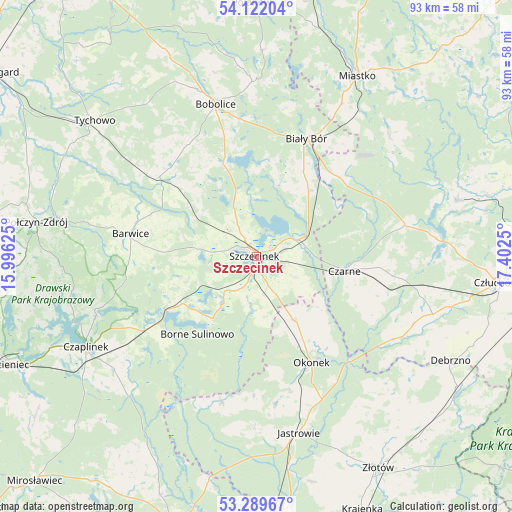
Szczecinek GPS coordinates[2]
53° 42' 28.476" North, 16° 41' 57.732" East
| Map corner | latitude | longitude |
|---|---|---|
| Upper-left | 54.12204°, | 15.99625° |
| Center: | 53.70791°, | 16.69937° |
| Lower-right: | 53.28967°, | 17.4025° |
| Map W x H: | 92.6×92.5 km | = 57.5×57.5mi |
| max Lat: | 54.83135° ⇑8.5% North |
| Szczecinek: | 53.70791° |
| min Lat: | ⇓91.5% South 49.21328° |
| min Long | Szczecinek | max Long |
| 14.20249° | 16.69937° | 24.03723° |
| W 11.9%⇐ | ⇒88.1% E |
Elevation
Elevation of Szczecinek is 139 m = 456 ft, and this is 52.4 m = 172 ft below average elevation for this country.
| Max E: |
974 m = 3196 ft | 63% |
| Avg. | 191.4 m = 628 ft | |
| Szczecinek | 139 m = 456 ft | |
Min E: |
-3 m = -10 ft | 37% |
See also: Poland elevation on elevation.city.
Geographical zone
Szczecinek is located in North temperate zone (between Tropic of Cancer and the Arctic Circle). Distance of this North polar circle is 1429.4 km =888.2 mi to North.| Distance of | km | miles | from Szczecinek |
|---|---|---|---|
| North Pole | 4035.3 | 2507.4 | to North |
| Arctic Circle | 1429.4 | 888.2 | to North |
| Tropic Cancer | 3365.8 | 2091.4 | to South |
| Equator | 5971.8 | 3710.7 | to South |


Nearby cities:
15 places around Szczecinek: (largest is in red/bold)
• Barwice
23 km =14.3 mi,  280°
280°
• Biały Bór
22.8 km =14.2 mi,  23°
23°
• Bobolice
28.4 km =17.6 mi,  345°
345°
• Borne Sulinowo
18.2 km =11.3 mi,  216°
216°
• Czarne
16 km =9.9 mi,  99°
99°
• Grzmiąca
22.6 km =14 mi,  309°
309°
• Jastrowie
32.9 km =20.4 mi,  166°
166°
• Koczała
32.5 km =20.2 mi,  47°
47°
• Lędyczek
25.8 km =16 mi,  137°
137°
• Okonek
21.6 km =13.4 mi,  152°
152°
• Rzeczenica
27.4 km =17 mi,  78°
78°
• Sitno
6 km =3.7 mi,  201°
201°
• Sypniewo
27.4 km =17 mi,  193°
193°
• Łubowo
24.4 km =15.2 mi,  236°
236°
• Żółtnica
8.2 km =5.1 mi,  117°
117°
Sources, notices
• [Note1] Compared only with cities in Poland existing in our database
• [Src1] Map data: © OpenStreetMap contributors (CC-BY-SA)
• [Src2] Other city data from geonames.org with taken over terms of usage.
• [Src3] Geographical zone / Annual Mean Temperature by Robert A. Rohde @ Wikipedia
