Kalisz Pomorski geodata
Kalisz Pomorski (West Pomerania) is a seat of a third-order administrative division; located in Poland in Europe/Warsaw (GMT+2) time zone. With population of 4,110 people, there are 791 cities with bigger population in this country. Compared to other cities in Poland, 87.5% of cities are located further ↓South; 93% of cities are located further →East and 83.7% of cities have higher elevation than Kalisz Pomorski. Note1
Administrative division(s):
- Level 1: West Pomerania
- Level 2: Powiat drawski
- Level 3: Kalisz Pomorski


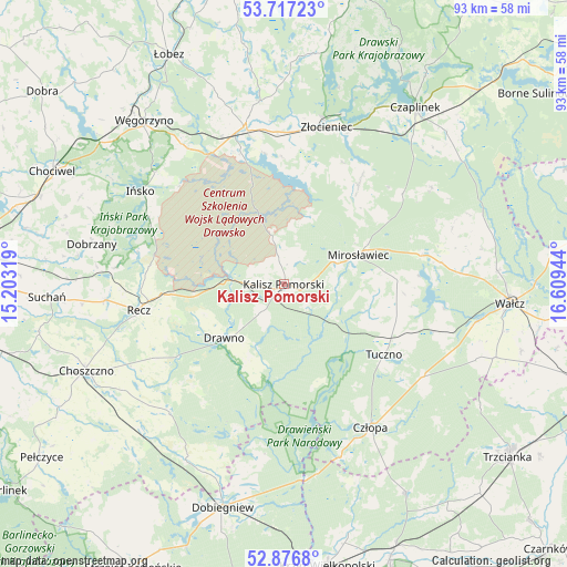
Kalisz Pomorski GPS coordinates[2]
53° 17' 56.688" North, 15° 54' 22.716" East
| Map corner | latitude | longitude |
|---|---|---|
| Upper-left | 53.71723°, | 15.20319° |
| Center: | 53.29908°, | 15.90631° |
| Lower-right: | 52.8768°, | 16.60944° |
| Map W x H: | 93.4×93.4 km | = 58×58mi |
| max Lat: | 54.83135° ⇑12.5% North |
| Kalisz Pomorski: | 53.29908° |
| min Lat: | ⇓87.5% South 49.21328° |
| min Long | Kalisz Pomorski | max Long |
| 14.20249° | 15.90631° | 24.03723° |
| W 7%⇐ | ⇒93% E |
Elevation
Elevation of Kalisz Pomorski is 92 m = 302 ft, and this is 99.4 m = 326 ft below average elevation for this country.
| Max E: |
974 m = 3196 ft | 83.7% |
| Avg. | 191.4 m = 628 ft | |
| Kalisz Pomorski | 92 m = 302 ft | |
Min E: |
-3 m = -10 ft | 16.3% |
See also: Poland elevation on elevation.city.
Geographical zone
Kalisz Pomorski is located in North temperate zone (between Tropic of Cancer and the Arctic Circle). Distance of this North polar circle is 1474.9 km =916.5 mi to North.| Distance of | km | miles | from Kalisz Pomorski |
|---|---|---|---|
| North Pole | 4080.8 | 2535.7 | to North |
| Arctic Circle | 1474.9 | 916.5 | to North |
| Tropic Cancer | 3320.4 | 2063.2 | to South |
| Equator | 5926.3 | 3682.4 | to South |


Nearby cities:
15 places around Kalisz Pomorski: (largest is in red/bold)
• Bierzwnik
33.4 km =20.8 mi,  208°
208°
• Choszczno
35.4 km =22 mi,  245°
245°
• Czaplinek
36 km =22.4 mi,  36°
36°
• Człopa
27.4 km =17 mi,  148°
148°
• Dobrzany
32.4 km =20.1 mi,  281°
281°
• Drawno
13.2 km =8.2 mi,  227°
227°
• Drawsko Pomorskie
26.5 km =16.5 mi,  346°
346°
• Ińsko
28.1 km =17.5 mi,  302°
302°
• Krzęcin
36.8 km =22.9 mi, 228°
• Mirosławiec
12.9 km =8 mi,  69°
69°
• Recz
24.3 km =15.1 mi,  259°
259°
• Tuczno
20.2 km =12.6 mi,  125°
125°
• Wierzchowo
22 km =13.7 mi, 35°
• Węgorzyno
35.4 km =22 mi,  319°
319°
• Złocieniec
26.9 km =16.7 mi,  14°
14°
Sources, notices
• [Note1] Compared only with cities in Poland existing in our database
• [Src1] Map data: © OpenStreetMap contributors (CC-BY-SA)
• [Src2] Other city data from geonames.org with taken over terms of usage.
• [Src3] Geographical zone / Annual Mean Temperature by Robert A. Rohde @ Wikipedia
