Parzęczew geodata
Parzęczew (Łódź Voivodeship) is a seat of a third-order administrative division; located in Poland in Europe/Warsaw (GMT+2) time zone. With population of 672 people, there are 3125 cities with bigger population in this country. Compared to other cities in Poland, 64.6% of cities are located further ↓South; 55.9% of cities are located further →East and 65% of cities have higher elevation than Parzęczew. Note1


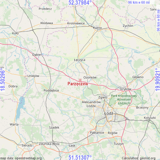
Parzęczew GPS coordinates[2]
51° 56' 54.78" North, 19° 12' 21.888" East
| Map corner | latitude | longitude |
|---|---|---|
| Upper-left | 52.37984°, | 18.50296° |
| Center: | 51.94855°, | 19.20608° |
| Lower-right: | 51.51307°, | 19.90921° |
| Map W x H: | 96.4×96.4 km | = 59.9×59.9mi |
| max Lat: | 54.83135° ⇑35.4% North |
| Parzęczew: | 51.94855° |
| min Lat: | ⇓64.6% South 49.21328° |
| min Long | Parzęczew | max Long |
| 14.20249° | 19.20608° | 24.03723° |
| W 44.1%⇐ | ⇒55.9% E |
Elevation
Elevation of Parzęczew is 133 m = 436 ft, and this is 58.4 m = 192 ft below average elevation for this country.
| Max E: |
974 m = 3196 ft | 65% |
| Avg. | 191.4 m = 628 ft | |
| Parzęczew | 133 m = 436 ft | |
Min E: |
-3 m = -10 ft | 35% |
See also: Poland elevation on elevation.city.
Geographical zone
Parzęczew is located in North temperate zone (between Tropic of Cancer and the Arctic Circle). Distance of this North polar circle is 1625 km =1009.7 mi to North.| Distance of | km | miles | from Parzęczew |
|---|---|---|---|
| North Pole | 4230.9 | 2629 | to North |
| Arctic Circle | 1625 | 1009.7 | to North |
| Tropic Cancer | 3170.2 | 1969.9 | to South |
| Equator | 5776.1 | 3589.1 | to South |


Nearby cities:
15 places around Parzęczew: (largest is in red/bold)
• Aleksandrów Łódzki
15.8 km =9.8 mi,  154°
154°
• Błonie
15 km =9.3 mi,  341°
341°
• Dalików
9.3 km =5.8 mi,  220°
220°
• Góra Świętej Małgorzaty
14.4 km =8.9 mi,  32°
32°
• Kazimierz
20.1 km =12.5 mi,  179°
179°
• Lutomiersk
21.7 km =13.5 mi, 179°
• Ozorków
6.1 km =3.8 mi,  74°
74°
• Piątek
23 km =14.3 mi,  54°
54°
• Poddębice
18.1 km =11.2 mi,  250°
250°
• Szczawin
20.1 km =12.5 mi,  105°
105°
• Wartkowice
14.3 km =8.9 mi,  282°
282°
• Witonia
22.9 km =14.2 mi,  16°
16°
• Zgierz
17.2 km =10.7 mi,  126°
126°
• Łęczyca
12.4 km =7.7 mi,  357°
357°
• Świnice Warckie
22.2 km =13.8 mi,  297°
297°
Sources, notices
• [Note1] Compared only with cities in Poland existing in our database
• [Src1] Map data: © OpenStreetMap contributors (CC-BY-SA)
• [Src2] Other city data from geonames.org with taken over terms of usage.
• [Src3] Geographical zone / Annual Mean Temperature by Robert A. Rohde @ Wikipedia
