Ozorków geodata
Ozorków (Łódź Voivodeship) is a seat of a third-order administrative division; located in Poland in Europe/Warsaw (GMT+2) time zone. With population of 20,608 people, there are 237 cities with bigger population in this country. Compared to other cities in Poland, 65% of cities are located further ↓South; 54.4% of cities are located further →East and 68.6% of cities have higher elevation than Ozorków. Note1


Ozorków GPS coordinates[2]
51° 57' 48.096" North, 19° 17' 29.004" East
| Map corner | latitude | longitude |
|---|---|---|
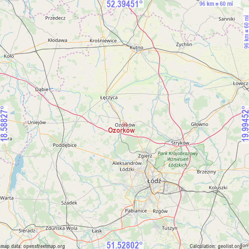
| Upper-left | 52.39451°, | 18.58827° |
| Center: | 51.96336°, | 19.29139° |
| Lower-right: | 51.52802°, | 19.99452° |
| Map W x H: | 96.3×96.3 km | = 59.8×59.8mi |
| max Lat: | 54.83135° ⇑35% North |
| Ozorków: | 51.96336° |
| min Lat: | ⇓65% South 49.21328° |
| min Long | Ozorków | max Long |
| 14.20249° | 19.29139° | 24.03723° |
| W 45.6%⇐ | ⇒54.4% E |
Elevation
Elevation of Ozorków is 124 m = 407 ft, and this is 67.4 m = 221 ft below average elevation for this country.
| Max E: |
974 m = 3196 ft | 68.6% |
| Avg. | 191.4 m = 628 ft | |
| Ozorków | 124 m = 407 ft | |
Min E: |
-3 m = -10 ft | 31.4% |
See also: Poland elevation on elevation.city.
Geographical zone
Ozorków is located in North temperate zone (between Tropic of Cancer and the Arctic Circle). Distance of this North polar circle is 1623.4 km =1008.7 mi to North.| Distance of | km | miles | from Ozorków |
|---|---|---|---|
| North Pole | 4229.3 | 2628 | to North |
| Arctic Circle | 1623.4 | 1008.7 | to North |
| Tropic Cancer | 3171.9 | 1970.9 | to South |
| Equator | 5777.8 | 3590.2 | to South |


Nearby cities:
15 places around Ozorków: (largest is in red/bold)
• Aleksandrów Łódzki
16 km =9.9 mi,  176°
176°
• Błonie
16.5 km =10.3 mi,  319°
319°
• Dalików
14.7 km =9.1 mi,  233°
233°
• Daszyna
22.6 km =14 mi,  340°
340°
• Dobra
21.3 km =13.2 mi,  119°
119°
• Góra Świętej Małgorzaty
10.6 km =6.6 mi,  10°
10°
• Kazimierz
22.5 km =14 mi,  195°
195°
• Parzęczew
6.1 km =3.8 mi,  254°
254°
• Piątek
17.4 km =10.8 mi,  47°
47°
• Stryków
22.6 km =14 mi,  107°
107°
• Szczawin
15.2 km =9.4 mi, 117°
• Wartkowice
19.9 km =12.4 mi,  274°
274°
• Witonia
20.4 km =12.7 mi,  1°
1°
• Zgierz
14.3 km =8.9 mi,  146°
146°
• Łęczyca
12.4 km =7.7 mi,  329°
329°
Sources, notices
• [Note1] Compared only with cities in Poland existing in our database
• [Src1] Map data: © OpenStreetMap contributors (CC-BY-SA)
• [Src2] Other city data from geonames.org with taken over terms of usage.
• [Src3] Geographical zone / Annual Mean Temperature by Robert A. Rohde @ Wikipedia
