Kawęczyn geodata
Kawęczyn (Lublin) is a populated place; located in Poland in Europe/Warsaw (GMT+2) time zone. With population of 515 people, there are 3504 cities with bigger population in this country. Compared to other cities in Poland, 60.4% of cities are located further ↓South; 84.9% of cities are located further ←West and 50.8% of cities have lower elevation than Kawęczyn. Note1


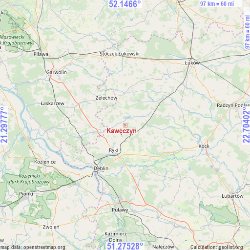
Kawęczyn GPS coordinates[2]
51° 42' 46.944" North, 22° 0' 3.204" East
| Map corner | latitude | longitude |
|---|---|---|
| Upper-left | 52.1466°, | 21.29777° |
| Center: | 51.71304°, | 22.00089° |
| Lower-right: | 51.27528°, | 22.70402° |
| Map W x H: | 96.9×96.9 km | = 60.2×60.2mi |
| max Lat: | 54.83135° ⇑39.6% North |
| Kawęczyn: | 51.71304° |
| min Lat: | ⇓60.4% South 49.21328° |
| min Long | Kawęczyn | max Long |
| 14.20249° | 22.00089° | 24.03723° |
| W 84.9%⇐ | ⇒15.1% E |
Elevation
Elevation of Kawęczyn is 174 m = 571 ft, and this is 17.4 m = 57 ft below average elevation for this country.
| Max E: |
974 m = 3196 ft | 49.2% |
| Avg. | 191.4 m = 628 ft | |
| Kawęczyn | 174 m = 571 ft | |
Min E: |
-3 m = -10 ft | 50.8% |
See also: Poland elevation on elevation.city.
Geographical zone
Kawęczyn is located in North temperate zone (between Tropic of Cancer and the Arctic Circle). Distance of this North polar circle is 1651.2 km =1026 mi to North.| Distance of | km | miles | from Kawęczyn |
|---|---|---|---|
| North Pole | 4257.1 | 2645.2 | to North |
| Arctic Circle | 1651.2 | 1026 | to North |
| Tropic Cancer | 3144 | 1953.6 | to South |
| Equator | 5750 | 3572.9 | to South |


Nearby cities:
15 places around Kawęczyn: (largest is in red/bold)
• Adamów
18.4 km =11.4 mi,  79°
79°
• Baranów
19.6 km =12.2 mi,  151°
151°
• Bobrowniki
18.8 km =11.7 mi,  194°
194°
• Dęblin
20.1 km =12.5 mi,  211°
211°
• Krzywda
16.5 km =10.3 mi,  56°
56°
• Kłoczew
2.6 km =1.6 mi,  290°
290°
• Moszczanka
12.8 km =8 mi, 190°
• Nowodwór
10.8 km =6.7 mi,  139°
139°
• Podebłocie
19.5 km =12.1 mi,  245°
245°
• Przytoczno
21.4 km =13.3 mi,  119°
119°
• Ryki
10.8 km =6.7 mi, 205°
• Stężyca
21.6 km =13.4 mi,  227°
227°
• Trojanów
13.3 km =8.3 mi,  259°
259°
• Ułęż
15.3 km =9.5 mi, 151°
• Żelechów
13 km =8.1 mi,  326°
326°
Sources, notices
• [Note1] Compared only with cities in Poland existing in our database
• [Src1] Map data: © OpenStreetMap contributors (CC-BY-SA)
• [Src2] Other city data from geonames.org with taken over terms of usage.
• [Src3] Geographical zone / Annual Mean Temperature by Robert A. Rohde @ Wikipedia
