Kłoczew geodata
Kłoczew (Lublin) is a seat of a third-order administrative division; located in Poland in Europe/Warsaw (GMT+2) time zone. With population of 886 people, there are 2702 cities with bigger population in this country. Compared to other cities in Poland, 60.6% of cities are located further ↓South; 84.4% of cities are located further ←West and 55.6% of cities have higher elevation than Kłoczew. Note1


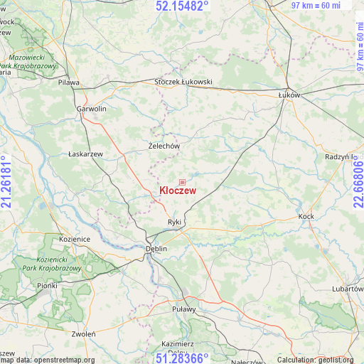
Kłoczew GPS coordinates[2]
51° 43' 16.824" North, 21° 57' 53.748" East
| Map corner | latitude | longitude |
|---|---|---|
| Upper-left | 52.15482°, | 21.26181° |
| Center: | 51.72134°, | 21.96493° |
| Lower-right: | 51.28366°, | 22.66806° |
| Map W x H: | 96.9×96.9 km | = 60.2×60.2mi |
| max Lat: | 54.83135° ⇑39.4% North |
| Kłoczew: | 51.72134° |
| min Lat: | ⇓60.6% South 49.21328° |
| min Long | Kłoczew | max Long |
| 14.20249° | 21.96493° | 24.03723° |
| W 84.4%⇐ | ⇒15.6% E |
Elevation
Elevation of Kłoczew is 157 m = 515 ft, and this is 34.4 m = 113 ft below average elevation for this country.
| Max E: |
974 m = 3196 ft | 55.6% |
| Avg. | 191.4 m = 628 ft | |
| Kłoczew | 157 m = 515 ft | |
Min E: |
-3 m = -10 ft | 44.4% |
See also: Poland elevation on elevation.city.
Geographical zone
Kłoczew is located in North temperate zone (between Tropic of Cancer and the Arctic Circle). Distance of this North polar circle is 1650.3 km =1025.4 mi to North.| Distance of | km | miles | from Kłoczew |
|---|---|---|---|
| North Pole | 4256.2 | 2644.7 | to North |
| Arctic Circle | 1650.3 | 1025.4 | to North |
| Tropic Cancer | 3145 | 1954.2 | to South |
| Equator | 5750.9 | 3573.4 | to South |


Nearby cities:
15 places around Kłoczew: (largest is in red/bold)
• Adamów
20.7 km =12.9 mi,  83°
83°
• Bobrowniki
19.3 km =12 mi,  186°
186°
• Dęblin
19.8 km =12.3 mi,  204°
204°
• Kawęczyn
2.6 km =1.6 mi,  110°
110°
• Krzywda
18.1 km =11.2 mi,  63°
63°
• Miastków Kościelny
20.5 km =12.7 mi,  332°
332°
• Moszczanka
13.5 km =8.4 mi,  179°
179°
• Nowodwór
13.1 km =8.1 mi,  134°
134°
• Podebłocie
17.7 km =11 mi,  239°
239°
• Ryki
10.9 km =6.8 mi, 191°
• Sobolew
20.8 km =12.9 mi,  274°
274°
• Stężyca
20.5 km =12.7 mi,  220°
220°
• Trojanów
11.1 km =6.9 mi,  253°
253°
• Ułęż
17.4 km =10.8 mi,  145°
145°
• Żelechów
11 km =6.8 mi, 334°
Sources, notices
• [Note1] Compared only with cities in Poland existing in our database
• [Src1] Map data: © OpenStreetMap contributors (CC-BY-SA)
• [Src2] Other city data from geonames.org with taken over terms of usage.
• [Src3] Geographical zone / Annual Mean Temperature by Robert A. Rohde @ Wikipedia
