Ryki geodata
Ryki (Lublin) is a seat of a second-order administrative division; located in Poland in Europe/Warsaw (GMT+2) time zone. With population of 9,619 people, there are 457 cities with bigger population in this country. Compared to other cities in Poland, 58.5% of cities are located further ↓South; 83.9% of cities are located further ←West and 58.7% of cities have higher elevation than Ryki. Note1


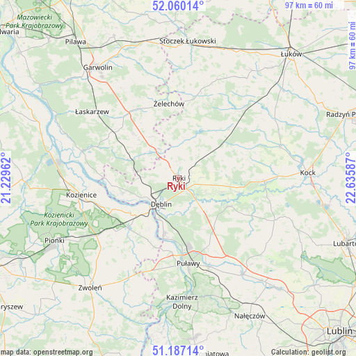
Ryki GPS coordinates[2]
51° 37' 32.664" North, 21° 55' 57.864" East
| Map corner | latitude | longitude |
|---|---|---|
| Upper-left | 52.06014°, | 21.22962° |
| Center: | 51.62574°, | 21.93274° |
| Lower-right: | 51.18714°, | 22.63587° |
| Map W x H: | 97.1×97.1 km | = 60.3×60.3mi |
| max Lat: | 54.83135° ⇑41.5% North |
| Ryki: | 51.62574° |
| min Lat: | ⇓58.5% South 49.21328° |
| min Long | Ryki | max Long |
| 14.20249° | 21.93274° | 24.03723° |
| W 83.9%⇐ | ⇒16.1% E |
Elevation
Elevation of Ryki is 149 m = 489 ft, and this is 42.4 m = 139 ft below average elevation for this country.
| Max E: |
974 m = 3196 ft | 58.7% |
| Avg. | 191.4 m = 628 ft | |
| Ryki | 149 m = 489 ft | |
Min E: |
-3 m = -10 ft | 41.3% |
See also: Poland elevation on elevation.city.
Geographical zone
Ryki is located in North temperate zone (between Tropic of Cancer and the Arctic Circle). Distance of this North polar circle is 1660.9 km =1032 mi to North.| Distance of | km | miles | from Ryki |
|---|---|---|---|
| North Pole | 4266.8 | 2651.3 | to North |
| Arctic Circle | 1660.9 | 1032 | to North |
| Tropic Cancer | 3134.3 | 1947.6 | to South |
| Equator | 5740.2 | 3566.8 | to South |


Nearby cities:
15 places around Ryki: (largest is in red/bold)
• Baranów
16 km =9.9 mi,  118°
118°
• Bałtów
16.3 km =10.1 mi,  157°
157°
• Bobrowniki
8.5 km =5.3 mi,  179°
179°
• Dęblin
9.4 km =5.8 mi,  218°
218°
• Gniewoszów
18.8 km =11.7 mi,  206°
206°
• Kawęczyn
10.8 km =6.7 mi,  25°
25°
• Kłoczew
10.9 km =6.8 mi,  11°
11°
• Moszczanka
3.7 km =2.3 mi,  141°
141°
• Nowodwór
11.8 km =7.3 mi,  82°
82°
• Paprotnia
18.7 km =11.6 mi,  271°
271°
• Podebłocie
13.1 km =8.1 mi,  277°
277°
• Stężyca
12.2 km =7.6 mi,  246°
246°
• Trojanów
11.2 km =7 mi,  311°
311°
• Ułęż
12.6 km =7.8 mi,  107°
107°
• Żyrzyn
17.9 km =11.1 mi, 142°
Sources, notices
• [Note1] Compared only with cities in Poland existing in our database
• [Src1] Map data: © OpenStreetMap contributors (CC-BY-SA)
• [Src2] Other city data from geonames.org with taken over terms of usage.
• [Src3] Geographical zone / Annual Mean Temperature by Robert A. Rohde @ Wikipedia
