Gniewoszów geodata
Gniewoszów (Mazovia) is a populated place; located in Poland in Europe/Warsaw (GMT+2) time zone. With population of 685 people, there are 3100 cities with bigger population in this country. Compared to other cities in Poland, 55.9% of cities are located further ↓South; 82.5% of cities are located further ←West and 71.1% of cities have higher elevation than Gniewoszów. Note1


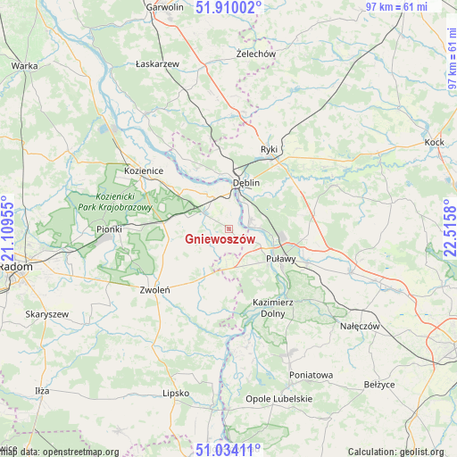
Gniewoszów GPS coordinates[2]
51° 28' 27.012" North, 21° 48' 45.612" East
| Map corner | latitude | longitude |
|---|---|---|
| Upper-left | 51.91002°, | 21.10955° |
| Center: | 51.47417°, | 21.81267° |
| Lower-right: | 51.03411°, | 22.5158° |
| Map W x H: | 97.4×97.4 km | = 60.5×60.5mi |
| max Lat: | 54.83135° ⇑44.1% North |
| Gniewoszów: | 51.47417° |
| min Lat: | ⇓55.9% South 49.21328° |
| min Long | Gniewoszów | max Long |
| 14.20249° | 21.81267° | 24.03723° |
| W 82.5%⇐ | ⇒17.5% E |
Elevation
Elevation of Gniewoszów is 119 m = 390 ft, and this is 72.4 m = 238 ft below average elevation for this country.
| Max E: |
974 m = 3196 ft | 71.1% |
| Avg. | 191.4 m = 628 ft | |
| Gniewoszów | 119 m = 390 ft | |
Min E: |
-3 m = -10 ft | 28.9% |
See also: Poland elevation on elevation.city.
Geographical zone
Gniewoszów is located in North temperate zone (between Tropic of Cancer and the Arctic Circle). Distance of this North polar circle is 1677.8 km =1042.5 mi to North.| Distance of | km | miles | from Gniewoszów |
|---|---|---|---|
| North Pole | 4283.7 | 2661.8 | to North |
| Arctic Circle | 1677.8 | 1042.5 | to North |
| Tropic Cancer | 3117.5 | 1937.1 | to South |
| Equator | 5723.4 | 3556.4 | to South |


Nearby cities:
15 places around Gniewoszów: (largest is in red/bold)
• Bałtów
14.7 km =9.1 mi,  83°
83°
• Bobrowniki
11.8 km =7.3 mi,  45°
45°
• Dęblin
9.8 km =6.1 mi,  14°
14°
• Garbatka-Letnisko
14 km =8.7 mi,  274°
274°
• Janików
19.3 km =12 mi,  303°
303°
• Janowiec
17.6 km =10.9 mi,  162°
162°
• Końskowola
18.1 km =11.2 mi,  113°
113°
• Moszczanka
17.6 km =10.9 mi,  37°
37°
• Podebłocie
19.1 km =11.9 mi,  345°
345°
• Policzna
13 km =8.1 mi,  260°
260°
• Przyłęk
19 km =11.8 mi,  193°
193°
• Puławy
12.6 km =7.8 mi,  120°
120°
• Ryki
18.8 km =11.7 mi,  26°
26°
• Stężyca
12.3 km =7.6 mi, 346°
• Łagów
12.7 km =7.9 mi,  199°
199°
Sources, notices
• [Note1] Compared only with cities in Poland existing in our database
• [Src1] Map data: © OpenStreetMap contributors (CC-BY-SA)
• [Src2] Other city data from geonames.org with taken over terms of usage.
• [Src3] Geographical zone / Annual Mean Temperature by Robert A. Rohde @ Wikipedia
