Stężyca geodata
Stężyca (Lublin) is a seat of a third-order administrative division; located in Poland in Europe/Warsaw (GMT+2) time zone. With population of 1,900 people, there are 1552 cities with bigger population in this country. Compared to other cities in Poland, 57.5% of cities are located further ↓South; 82% of cities are located further ←West and 74% of cities have higher elevation than Stężyca. Note1


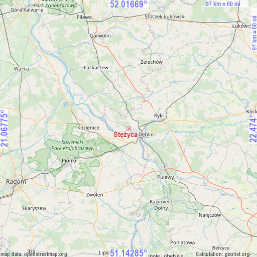
Stężyca GPS coordinates[2]
51° 34' 54.732" North, 21° 46' 15.132" East
| Map corner | latitude | longitude |
|---|---|---|
| Upper-left | 52.01669°, | 21.06775° |
| Center: | 51.58187°, | 21.77087° |
| Lower-right: | 51.14285°, | 22.474° |
| Map W x H: | 97.2×97.2 km | = 60.4×60.4mi |
| max Lat: | 54.83135° ⇑42.5% North |
| Stężyca: | 51.58187° |
| min Lat: | ⇓57.5% South 49.21328° |
| min Long | Stężyca | max Long |
| 14.20249° | 21.77087° | 24.03723° |
| W 82%⇐ | ⇒18% E |
Elevation
Elevation of Stężyca is 113 m = 371 ft, and this is 78.4 m = 257 ft below average elevation for this country.
| Max E: |
974 m = 3196 ft | 74% |
| Avg. | 191.4 m = 628 ft | |
| Stężyca | 113 m = 371 ft | |
Min E: |
-3 m = -10 ft | 26% |
See also: Poland elevation on elevation.city.
Geographical zone
Stężyca is located in North temperate zone (between Tropic of Cancer and the Arctic Circle). Distance of this North polar circle is 1665.8 km =1035.1 mi to North.| Distance of | km | miles | from Stężyca |
|---|---|---|---|
| North Pole | 4271.7 | 2654.3 | to North |
| Arctic Circle | 1665.8 | 1035.1 | to North |
| Tropic Cancer | 3129.4 | 1944.5 | to South |
| Equator | 5735.4 | 3563.8 | to South |


Nearby cities:
15 places around Stężyca: (largest is in red/bold)
• Bobrowniki
11.8 km =7.3 mi,  108°
108°
• Dęblin
5.9 km =3.7 mi,  115°
115°
• Garbatka-Letnisko
15.6 km =9.7 mi,  225°
225°
• Gniewoszów
12.3 km =7.6 mi,  166°
166°
• Janików
13.1 km =8.1 mi,  264°
264°
• Kobylnica
15.2 km =9.4 mi,  297°
297°
• Kozienice
15.4 km =9.6 mi,  270°
270°
• Maciejowice
19.4 km =12.1 mi,  309°
309°
• Moszczanka
13.6 km =8.5 mi,  81°
81°
• Paprotnia
9.3 km =5.8 mi, 306°
• Podebłocie
6.7 km =4.2 mi,  344°
344°
• Policzna
17.2 km =10.7 mi,  215°
215°
• Ryki
12.2 km =7.6 mi,  66°
66°
• Sobolew
18.7 km =11.6 mi, 336°
• Trojanów
12.6 km =7.8 mi,  12°
12°
Sources, notices
• [Note1] Compared only with cities in Poland existing in our database
• [Src1] Map data: © OpenStreetMap contributors (CC-BY-SA)
• [Src2] Other city data from geonames.org with taken over terms of usage.
• [Src3] Geographical zone / Annual Mean Temperature by Robert A. Rohde @ Wikipedia
