Regimin geodata
Regimin (Mazovia) is a seat of a third-order administrative division; located in Poland in Europe/Warsaw (GMT+2) time zone. With population of 523 people, there are 3473 cities with bigger population in this country. Compared to other cities in Poland, 82.8% of cities are located further ↓South; 65.7% of cities are located further ←West and 67.4% of cities have higher elevation than Regimin. Note1


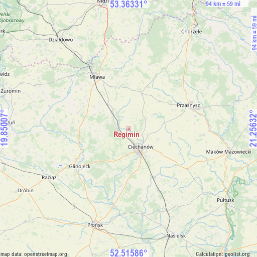
Regimin GPS coordinates[2]
52° 56' 29.976" North, 20° 33' 11.484" East
| Map corner | latitude | longitude |
|---|---|---|
| Upper-left | 53.36331°, | 19.85007° |
| Center: | 52.94166°, | 20.55319° |
| Lower-right: | 52.51586°, | 21.25632° |
| Map W x H: | 94.2×94.2 km | = 58.5×58.5mi |
| max Lat: | 54.83135° ⇑17.2% North |
| Regimin: | 52.94166° |
| min Lat: | ⇓82.8% South 49.21328° |
| min Long | Regimin | max Long |
| 14.20249° | 20.55319° | 24.03723° |
| W 65.7%⇐ | ⇒34.3% E |
Elevation
Elevation of Regimin is 127 m = 417 ft, and this is 64.4 m = 211 ft below average elevation for this country.
| Max E: |
974 m = 3196 ft | 67.4% |
| Avg. | 191.4 m = 628 ft | |
| Regimin | 127 m = 417 ft | |
Min E: |
-3 m = -10 ft | 32.6% |
See also: Poland elevation on elevation.city.
Geographical zone
Regimin is located in North temperate zone (between Tropic of Cancer and the Arctic Circle). Distance of this North polar circle is 1514.6 km =941.1 mi to North.| Distance of | km | miles | from Regimin |
|---|---|---|---|
| North Pole | 4120.5 | 2560.4 | to North |
| Arctic Circle | 1514.6 | 941.1 | to North |
| Tropic Cancer | 3280.6 | 2038.5 | to South |
| Equator | 5886.6 | 3657.8 | to South |


Nearby cities:
15 places around Regimin: (largest is in red/bold)
• Ciechanów
8.1 km =5 mi,  146°
146°
• Czernice Borowe
15 km =9.3 mi,  47°
47°
• Dzierzgowo
24.6 km =15.3 mi,  17°
17°
• Glinojeck
22.2 km =13.8 mi,  232°
232°
• Gołotczyzna
19.3 km =12 mi, 151°
• Grudusk
13.8 km =8.6 mi, 20°
• Mława
22.1 km =13.7 mi,  329°
329°
• Ojrzeń
19.6 km =12.2 mi,  181°
181°
• Opinogóra Górna
11.7 km =7.3 mi,  109°
109°
• Przasnysz
23.5 km =14.6 mi,  68°
68°
• Sońsk
20.3 km =12.6 mi, 151°
• Strzegowo
18.7 km =11.6 mi,  253°
253°
• Stupsk
11.9 km =7.4 mi,  319°
319°
• Szydłowo
16.9 km =10.5 mi,  336°
336°
• Wiśniewo
19.4 km =12.1 mi,  314°
314°
Sources, notices
• [Note1] Compared only with cities in Poland existing in our database
• [Src1] Map data: © OpenStreetMap contributors (CC-BY-SA)
• [Src2] Other city data from geonames.org with taken over terms of usage.
• [Src3] Geographical zone / Annual Mean Temperature by Robert A. Rohde @ Wikipedia
