Świercze geodata
Świercze (Mazovia) is a seat of a third-order administrative division; located in Poland in Europe/Warsaw (GMT+2) time zone. With population of 672 people, there are 3125 cities with bigger population in this country. Compared to other cities in Poland, 78.9% of cities are located further ↓South; 68.6% of cities are located further ←West and 57.6% of cities have higher elevation than Świercze. Note1


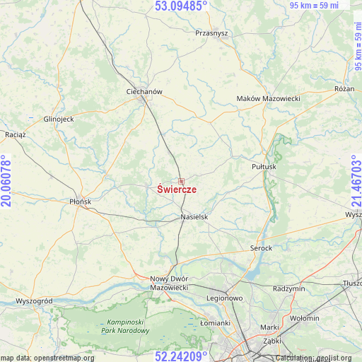
Świercze GPS coordinates[2]
52° 40' 13.98" North, 20° 45' 50.04" East
| Map corner | latitude | longitude |
|---|---|---|
| Upper-left | 53.09485°, | 20.06078° |
| Center: | 52.67055°, | 20.7639° |
| Lower-right: | 52.24209°, | 21.46703° |
| Map W x H: | 94.8×94.8 km | = 58.9×58.9mi |
| max Lat: | 54.83135° ⇑21.1% North |
| Świercze: | 52.67055° |
| min Lat: | ⇓78.9% South 49.21328° |
| min Long | Świercze | max Long |
| 14.20249° | 20.7639° | 24.03723° |
| W 68.6%⇐ | ⇒31.4% E |
Elevation
Elevation of Świercze is 152 m = 499 ft, and this is 39.4 m = 129 ft below average elevation for this country.
| Max E: |
974 m = 3196 ft | 57.6% |
| Avg. | 191.4 m = 628 ft | |
| Świercze | 152 m = 499 ft | |
Min E: |
-3 m = -10 ft | 42.4% |
See also: Poland elevation on elevation.city.
Geographical zone
Świercze is located in North temperate zone (between Tropic of Cancer and the Arctic Circle). Distance of this North polar circle is 1544.8 km =959.9 mi to North.| Distance of | km | miles | from Świercze |
|---|---|---|---|
| North Pole | 4150.6 | 2579.1 | to North |
| Arctic Circle | 1544.8 | 959.9 | to North |
| Tropic Cancer | 3250.5 | 2019.8 | to South |
| Equator | 5856.4 | 3639 | to South |


Nearby cities:
15 places around Świercze: (largest is in red/bold)
• Brody-Parcele
21.4 km =13.3 mi,  182°
182°
• Gołotczyzna
14.1 km =8.8 mi,  339°
339°
• Gołymin-Ośrodek
17 km =10.6 mi,  25°
25°
• Gzy
14.4 km =8.9 mi,  57°
57°
• Gąsocin
8.2 km =5.1 mi,  334°
334°
• Joniec
14.5 km =9 mi,  237°
237°
• Nasielsk
9.5 km =5.9 mi,  162°
162°
• Nowe Miasto
9.3 km =5.8 mi,  260°
260°
• Ojrzeń
18.2 km =11.3 mi,  305°
305°
• Pokrzywnica
18.1 km =11.2 mi,  107°
107°
• Pomiechówek
22.3 km =13.9 mi,  186°
186°
• Pułtusk
21.8 km =13.5 mi,  80°
80°
• Sochocin
19.7 km =12.2 mi,  275°
275°
• Sońsk
13.1 km =8.1 mi, 340°
• Winnica
12.3 km =7.6 mi,  104°
104°
Sources, notices
• [Note1] Compared only with cities in Poland existing in our database
• [Src1] Map data: © OpenStreetMap contributors (CC-BY-SA)
• [Src2] Other city data from geonames.org with taken over terms of usage.
• [Src3] Geographical zone / Annual Mean Temperature by Robert A. Rohde @ Wikipedia
