Sochocin geodata
Sochocin (Mazovia) is a seat of a third-order administrative division; located in Poland in Europe/Warsaw (GMT+2) time zone. With population of 1,945 people, there are 1520 cities with bigger population in this country. Compared to other cities in Poland, 79.1% of cities are located further ↓South; 64.7% of cities are located further ←West and 84.1% of cities have higher elevation than Sochocin. Note1


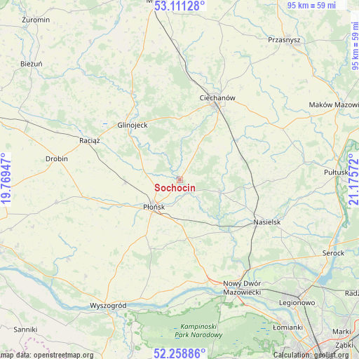
Sochocin GPS coordinates[2]
52° 41' 13.74" North, 20° 28' 21.324" East
| Map corner | latitude | longitude |
|---|---|---|
| Upper-left | 53.11128°, | 19.76947° |
| Center: | 52.68715°, | 20.47259° |
| Lower-right: | 52.25886°, | 21.17572° |
| Map W x H: | 94.8×94.8 km | = 58.9×58.9mi |
| max Lat: | 54.83135° ⇑20.9% North |
| Sochocin: | 52.68715° |
| min Lat: | ⇓79.1% South 49.21328° |
| min Long | Sochocin | max Long |
| 14.20249° | 20.47259° | 24.03723° |
| W 64.7%⇐ | ⇒35.3% E |
Elevation
Elevation of Sochocin is 91 m = 299 ft, and this is 100.4 m = 329 ft below average elevation for this country.
| Max E: |
974 m = 3196 ft | 84.1% |
| Avg. | 191.4 m = 628 ft | |
| Sochocin | 91 m = 299 ft | |
Min E: |
-3 m = -10 ft | 15.9% |
See also: Poland elevation on elevation.city.
Geographical zone
Sochocin is located in North temperate zone (between Tropic of Cancer and the Arctic Circle). Distance of this North polar circle is 1542.9 km =958.7 mi to North.| Distance of | km | miles | from Sochocin |
|---|---|---|---|
| North Pole | 4148.8 | 2577.9 | to North |
| Arctic Circle | 1542.9 | 958.7 | to North |
| Tropic Cancer | 3252.3 | 2020.9 | to South |
| Equator | 5858.3 | 3640.2 | to South |


Nearby cities:
15 places around Sochocin: (largest is in red/bold)
• Baboszewo
14.7 km =9.1 mi,  267°
267°
• Ciechanów
23.8 km =14.8 mi,  24°
24°
• Dzierzążnia
17.4 km =10.8 mi,  247°
247°
• Glinojeck
19.1 km =11.9 mi,  320°
320°
• Gołotczyzna
18.6 km =11.6 mi,  52°
52°
• Gąsocin
17.1 km =10.6 mi,  70°
70°
• Joniec
12.1 km =7.5 mi,  142°
142°
• Naruszewo
19.6 km =12.2 mi,  204°
204°
• Nasielsk
25 km =15.5 mi,  115°
115°
• Nowe Miasto
11 km =6.8 mi,  107°
107°
• Ojrzeń
9.9 km =6.2 mi,  28°
28°
• Płońsk
9.6 km =6 mi,  222°
222°
• Sońsk
18.5 km =11.5 mi,  55°
55°
• Załuski
19.9 km =12.4 mi,  169°
169°
• Świercze
19.7 km =12.2 mi,  95°
95°
Sources, notices
• [Note1] Compared only with cities in Poland existing in our database
• [Src1] Map data: © OpenStreetMap contributors (CC-BY-SA)
• [Src2] Other city data from geonames.org with taken over terms of usage.
• [Src3] Geographical zone / Annual Mean Temperature by Robert A. Rohde @ Wikipedia
