Pułtusk geodata
Pułtusk (Mazovia) is a seat of a second-order administrative division; located in Poland in Europe/Warsaw (GMT+2) time zone. With population of 19,039 people, there are 253 cities with bigger population in this country. Compared to other cities in Poland, 79.3% of cities are located further ↓South; 74.2% of cities are located further ←West and 82.2% of cities have higher elevation than Pułtusk. Note1


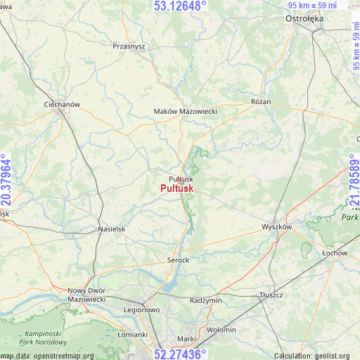
Pułtusk GPS coordinates[2]
52° 42' 9" North, 21° 4' 57.936" East
| Map corner | latitude | longitude |
|---|---|---|
| Upper-left | 53.12648°, | 20.37964° |
| Center: | 52.7025°, | 21.08276° |
| Lower-right: | 52.27436°, | 21.78589° |
| Map W x H: | 94.7×94.7 km | = 58.8×58.8mi |
| max Lat: | 54.83135° ⇑20.7% North |
| Pułtusk: | 52.7025° |
| min Lat: | ⇓79.3% South 49.21328° |
| min Long | Pułtusk | max Long |
| 14.20249° | 21.08276° | 24.03723° |
| W 74.2%⇐ | ⇒25.8% E |
Elevation
Elevation of Pułtusk is 95 m = 312 ft, and this is 96.4 m = 316 ft below average elevation for this country.
| Max E: |
974 m = 3196 ft | 82.2% |
| Avg. | 191.4 m = 628 ft | |
| Pułtusk | 95 m = 312 ft | |
Min E: |
-3 m = -10 ft | 17.8% |
See also: Poland elevation on elevation.city.
Geographical zone
Pułtusk is located in North temperate zone (between Tropic of Cancer and the Arctic Circle). Distance of this North polar circle is 1541.2 km =957.7 mi to North.| Distance of | km | miles | from Pułtusk |
|---|---|---|---|
| North Pole | 4147.1 | 2576.9 | to North |
| Arctic Circle | 1541.2 | 957.7 | to North |
| Tropic Cancer | 3254 | 2021.9 | to South |
| Equator | 5860 | 3641.2 | to South |


Nearby cities:
15 places around Pułtusk: (largest is in red/bold)
• Gołymin-Ośrodek
18.3 km =11.4 mi,  309°
309°
• Gzy
10.3 km =6.4 mi,  294°
294°
• Karniewo
16.2 km =10.1 mi,  337°
337°
• Maków Mazowiecki
18.1 km =11.2 mi,  3°
3°
• Obryte
11.3 km =7 mi,  82°
82°
• Pokrzywnica
10.1 km =6.3 mi,  205°
205°
• Psary
7.4 km =4.6 mi, 79°
• Rzewnie
22.6 km =14 mi,  49°
49°
• Rząśnik
19.2 km =11.9 mi,  86°
86°
• Serock
21.4 km =13.3 mi,  182°
182°
• Somianka
21.2 km =13.2 mi,  137°
137°
• Szelków
17.3 km =10.7 mi,  31°
31°
• Winnica
11.6 km =7.2 mi,  235°
235°
• Zatory
13.3 km =8.3 mi,  149°
149°
• Świercze
21.8 km =13.5 mi,  260°
260°
Sources, notices
• [Note1] Compared only with cities in Poland existing in our database
• [Src1] Map data: © OpenStreetMap contributors (CC-BY-SA)
• [Src2] Other city data from geonames.org with taken over terms of usage.
• [Src3] Geographical zone / Annual Mean Temperature by Robert A. Rohde @ Wikipedia
