Rogów geodata
Rogów (Świętokrzyskie) is a populated place; located in Poland in Europe/Warsaw (GMT+2) time zone. With population of 1,300 people, there are 2055 cities with bigger population in this country. Compared to other cities in Poland, 51% of cities are located further ↓South; 64.1% of cities are located further ←West and 72.1% of cities have lower elevation than Rogów. Note1


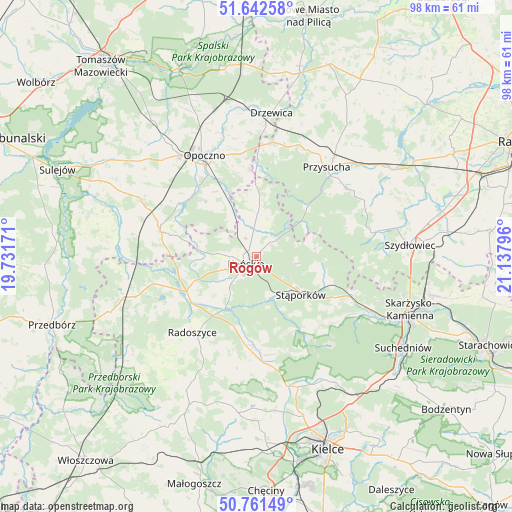
Rogów GPS coordinates[2]
51° 12' 14.904" North, 20° 26' 5.388" East
| Map corner | latitude | longitude |
|---|---|---|
| Upper-left | 51.64258°, | 19.73171° |
| Center: | 51.20414°, | 20.43483° |
| Lower-right: | 50.76149°, | 21.13796° |
| Map W x H: | 98×98 km | = 60.9×60.9mi |
| max Lat: | 54.83135° ⇑49% North |
| Rogów: | 51.20414° |
| min Lat: | ⇓51% South 49.21328° |
| min Long | Rogów | max Long |
| 14.20249° | 20.43483° | 24.03723° |
| W 64.1%⇐ | ⇒35.9% E |
Elevation
Elevation of Rogów is 236 m = 774 ft, and this is 44.6 m = 146 ft above average elevation for this country.
| Max E: |
974 m = 3196 ft | 27.9% |
| Rogów | 236 m 774 ft | |
| Avg. | 191.4 m = 628 ft | |
Min E: |
-3 m = -10 ft | 72.1% |
See also: Poland elevation on elevation.city.
Geographical zone
Rogów is located in North temperate zone (between Tropic of Cancer and the Arctic Circle). Distance of this North polar circle is 1707.8 km =1061.2 mi to North.| Distance of | km | miles | from Rogów |
|---|---|---|---|
| North Pole | 4313.7 | 2680.4 | to North |
| Arctic Circle | 1707.8 | 1061.2 | to North |
| Tropic Cancer | 3087.4 | 1918.4 | to South |
| Equator | 5693.4 | 3537.7 | to South |


Nearby cities:
15 places around Rogów: (largest is in red/bold)
• Białaczów
14.2 km =8.8 mi,  317°
317°
• Borkowice
21.6 km =13.4 mi,  53°
53°
• Gowarczów
8.3 km =5.2 mi,  1°
1°
• Końskie
2.4 km =1.5 mi,  235°
235°
• Mniów
21.6 km =13.4 mi,  170°
170°
• Mroczków Gościnny
19.8 km =12.3 mi,  351°
351°
• Opoczno
22 km =13.7 mi,  330°
330°
• Przysucha
21.8 km =13.5 mi,  38°
38°
• Radoszyce
19 km =11.8 mi,  220°
220°
• Ruda Maleniecka
16.1 km =10 mi,  246°
246°
• Smyków
17.9 km =11.1 mi,  187°
187°
• Stąporków
12.1 km =7.5 mi,  127°
127°
• Wielka Wieś
11.1 km =6.9 mi,  98°
98°
• Świerczów
16.9 km =10.5 mi, 126°
• Żarnów
18.7 km =11.6 mi,  284°
284°
Sources, notices
• [Note1] Compared only with cities in Poland existing in our database
• [Src1] Map data: © OpenStreetMap contributors (CC-BY-SA)
• [Src2] Other city data from geonames.org with taken over terms of usage.
• [Src3] Geographical zone / Annual Mean Temperature by Robert A. Rohde @ Wikipedia
