Mazowszany geodata
Mazowszany (Mazovia) is a populated place; located in Poland in Europe/Warsaw (GMT+2) time zone. With population of 565 people, there are 3369 cities with bigger population in this country. Compared to other cities in Poland, 53.8% of cities are located further ↓South; 74.9% of cities are located further ←West and 54.6% of cities have lower elevation than Mazowszany. Note1


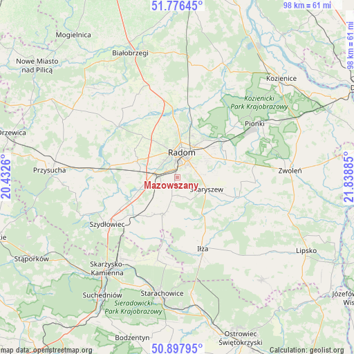
Mazowszany GPS coordinates[2]
51° 20' 21.48" North, 21° 8' 8.592" East
| Map corner | latitude | longitude |
|---|---|---|
| Upper-left | 51.77645°, | 20.4326° |
| Center: | 51.3393°, | 21.13572° |
| Lower-right: | 50.89795°, | 21.83885° |
| Map W x H: | 97.7×97.7 km | = 60.7×60.7mi |
| max Lat: | 54.83135° ⇑46.2% North |
| Mazowszany: | 51.3393° |
| min Lat: | ⇓53.8% South 49.21328° |
| min Long | Mazowszany | max Long |
| 14.20249° | 21.13572° | 24.03723° |
| W 74.9%⇐ | ⇒25.1% E |
Elevation
Elevation of Mazowszany is 184 m = 604 ft, and this is 7.4 m = 24 ft below average elevation for this country.
| Max E: |
974 m = 3196 ft | 45.4% |
| Avg. | 191.4 m = 628 ft | |
| Mazowszany | 184 m = 604 ft | |
Min E: |
-3 m = -10 ft | 54.6% |
See also: Poland elevation on elevation.city.
Geographical zone
Mazowszany is located in North temperate zone (between Tropic of Cancer and the Arctic Circle). Distance of this North polar circle is 1692.8 km =1051.9 mi to North.| Distance of | km | miles | from Mazowszany |
|---|---|---|---|
| North Pole | 4298.7 | 2671.1 | to North |
| Arctic Circle | 1692.8 | 1051.9 | to North |
| Tropic Cancer | 3102.5 | 1927.8 | to South |
| Equator | 5708.4 | 3547 | to South |


Nearby cities:
15 places around Mazowszany: (largest is in red/bold)
• Jastrząb
16.6 km =10.3 mi,  231°
231°
• Jedlnia-Letnisko
17.2 km =10.7 mi,  53°
53°
• Kowala
4.9 km =3 mi,  250°
250°
• Ludwinów
3 km =1.9 mi,  289°
289°
• Maków
8.2 km =5.1 mi,  85°
85°
• Orońsko
10.5 km =6.5 mi, 254°
• Pakosław
16.6 km =10.3 mi,  170°
170°
• Radom
7.1 km =4.4 mi,  6°
6°
• Rzeczków
9.6 km =6 mi,  213°
213°
• Skaryszew
8.7 km =5.4 mi,  111°
111°
• Sławno
10.1 km =6.3 mi,  301°
301°
• Trablice
1.5 km =0.9 mi,  341°
341°
• Wierzbica
10.7 km =6.6 mi,  200°
200°
• Wolanów
11.9 km =7.4 mi, 292°
• Zakrzew
14.7 km =9.1 mi,  320°
320°
Sources, notices
• [Note1] Compared only with cities in Poland existing in our database
• [Src1] Map data: © OpenStreetMap contributors (CC-BY-SA)
• [Src2] Other city data from geonames.org with taken over terms of usage.
• [Src3] Geographical zone / Annual Mean Temperature by Robert A. Rohde @ Wikipedia
