Wólka Niedźwiedzka geodata
Wólka Niedźwiedzka (Subcarpathian) is a populated place; located in Poland in Europe/Warsaw (GMT+2) time zone. With population of 1,800 people, there are 1605 cities with bigger population in this country. Compared to other cities in Poland, 73.4% of cities are located further ↑North; 87.3% of cities are located further ←West and 58.8% of cities have lower elevation than Wólka Niedźwiedzka. Note1
Administrative division(s):
- Level 1: Subcarpathian
- Level 2: Powiat rzeszowski
- Level 3: Sokołów Małopolski


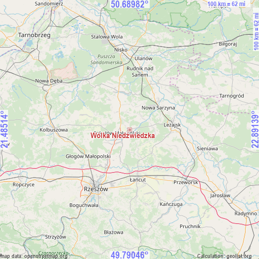
Wólka Niedźwiedzka GPS coordinates[2]
50° 14' 32.136" North, 22° 11' 17.736" East
| Map corner | latitude | longitude |
|---|---|---|
| Upper-left | 50.68982°, | 21.48514° |
| Center: | 50.24226°, | 22.18826° |
| Lower-right: | 49.79046°, | 22.89139° |
| Map W x H: | 100×100 km | = 62.1×62.1mi |
| max Lat: | 54.83135° ⇑73.4% North |
| Wólka Niedźwiedzka: | 50.24226° |
| min Lat: | ⇓26.6% South 49.21328° |
| min Long | Wólka Niedźwi | max Long |
| 14.20249° | 22.18826° | 24.03723° |
| W 87.3%⇐ | ⇒12.7% E |
Elevation
Elevation of Wólka Niedźwiedzka is 196 m = 643 ft, and this is 4.6 m = 15 ft above average elevation for this country.
| Max E: |
974 m = 3196 ft | 41.2% |
| Wólka Niedźwiedzka | 196 m 643 ft | |
| Avg. | 191.4 m = 628 ft | |
Min E: |
-3 m = -10 ft | 58.8% |
See also: Poland elevation on elevation.city.
Geographical zone
Wólka Niedźwiedzka is located in North temperate zone (between Tropic of Cancer and the Arctic Circle). Distance of this North polar circle is 1814.8 km =1127.7 mi to North.| Distance of | km | miles | from Wólka Niedźwiedzka |
|---|---|---|---|
| North Pole | 4420.6 | 2746.8 | to North |
| Arctic Circle | 1814.8 | 1127.7 | to North |
| Tropic Cancer | 2980.5 | 1852 | to South |
| Equator | 5586.4 | 3471.2 | to South |


Nearby cities:
15 places around Wólka Niedźwiedzka: (largest is in red/bold)
• Brzóza Królewska
9.8 km =6.1 mi,  92°
92°
• Brzóza Stadnicka
8.2 km =5.1 mi,  125°
125°
• Cholewiana Góra
14.4 km =8.9 mi,  326°
326°
• Czarna
14.7 km =9.1 mi,  181°
181°
• Górno
5.4 km =3.4 mi, 325°
• Hucisko
8.8 km =5.5 mi,  63°
63°
• Kamień
11.6 km =7.2 mi,  341°
341°
• Nowa Sarzyna
14.1 km =8.8 mi,  51°
51°
• Rakszawa
9.8 km =6.1 mi,  158°
158°
• Sokołów Małopolski
5.1 km =3.2 mi,  253°
253°
• Wola Żarczycka
7 km =4.3 mi,  38°
38°
• Wólka Podleśna
14.9 km =9.3 mi,  201°
201°
• Wólka Łętowska
9.1 km =5.7 mi,  8°
8°
• Łętownia
9.7 km =6 mi,  19°
19°
• Żołynia
12.4 km =7.7 mi,  136°
136°
Sources, notices
• [Note1] Compared only with cities in Poland existing in our database
• [Src1] Map data: © OpenStreetMap contributors (CC-BY-SA)
• [Src2] Other city data from geonames.org with taken over terms of usage.
• [Src3] Geographical zone / Annual Mean Temperature by Robert A. Rohde @ Wikipedia
