Czarna geodata
Czarna (Subcarpathian) is a seat of a third-order administrative division; located in Poland in Europe/Warsaw (GMT+2) time zone. With population of 1,600 people, there are 1751 cities with bigger population in this country. Compared to other cities in Poland, 77.5% of cities are located further ↑North; 87.2% of cities are located further ←West and 57.5% of cities have lower elevation than Czarna. Note1


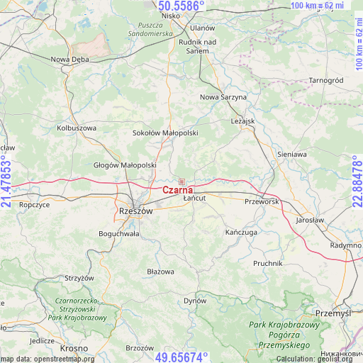
Czarna GPS coordinates[2]
50° 6' 35.244" North, 22° 10' 53.94" East
| Map corner | latitude | longitude |
|---|---|---|
| Upper-left | 50.5586°, | 21.47853° |
| Center: | 50.10979°, | 22.18165° |
| Lower-right: | 49.65674°, | 22.88478° |
| Map W x H: | 100.3×100.3 km | = 62.3×62.3mi |
| max Lat: | 54.83135° ⇑77.5% North |
| Czarna: | 50.10979° |
| min Lat: | ⇓22.5% South 49.21328° |
| min Long | Czarna | max Long |
| 14.20249° | 22.18165° | 24.03723° |
| W 87.2%⇐ | ⇒12.8% E |
Elevation
Elevation of Czarna is 192 m = 630 ft, and this is 0.59999999999999 m = 2 ft above average elevation for this country.
| Max E: |
974 m = 3196 ft | 42.5% |
| Czarna | 192 m 630 ft | |
| Avg. | 191.4 m = 628 ft | |
Min E: |
-3 m = -10 ft | 57.5% |
See also: Poland elevation on elevation.city.
Geographical zone
Czarna is located in North temperate zone (between Tropic of Cancer and the Arctic Circle). Distance of this North polar circle is 1829.5 km =1136.8 mi to North.| Distance of | km | miles | from Czarna |
|---|---|---|---|
| North Pole | 4435.4 | 2756 | to North |
| Arctic Circle | 1829.5 | 1136.8 | to North |
| Tropic Cancer | 2965.8 | 1842.9 | to South |
| Equator | 5571.7 | 3462.1 | to South |


Nearby cities:
15 places around Czarna: (largest is in red/bold)
• Albigowa
11 km =6.8 mi,  164°
164°
• Białobrzegi
9.8 km =6.1 mi,  94°
94°
• Brzóza Stadnicka
12.3 km =7.6 mi,  35°
35°
• Głuchów
7.1 km =4.4 mi,  116°
116°
• Kosina
11.3 km =7 mi,  111°
111°
• Kraczkowa
8 km =5 mi,  186°
186°
• Krasne
9 km =5.6 mi,  228°
228°
• Krzemienica
5.3 km =3.3 mi,  180°
180°
• Rakszawa
7 km =4.3 mi, 35°
• Sonina
8.1 km =5 mi,  132°
132°
• Trzebownisko
10.9 km =6.8 mi,  251°
251°
• Wysoka
9.1 km =5.7 mi,  142°
142°
• Wólka Podleśna
5 km =3.1 mi,  280°
280°
• Łańcut
5.7 km =3.5 mi, 143°
• Żołynia
10.7 km =6.6 mi,  57°
57°
Sources, notices
• [Note1] Compared only with cities in Poland existing in our database
• [Src1] Map data: © OpenStreetMap contributors (CC-BY-SA)
• [Src2] Other city data from geonames.org with taken over terms of usage.
• [Src3] Geographical zone / Annual Mean Temperature by Robert A. Rohde @ Wikipedia
