Łętownia geodata
Łętownia (Subcarpathian) is a populated place; located in Poland in Europe/Warsaw (GMT+2) time zone. With population of 1,450 people, there are 1914 cities with bigger population in this country. Compared to other cities in Poland, 71.5% of cities are located further ↑North; 87.8% of cities are located further ←West and 56.8% of cities have lower elevation than Łętownia. Note1


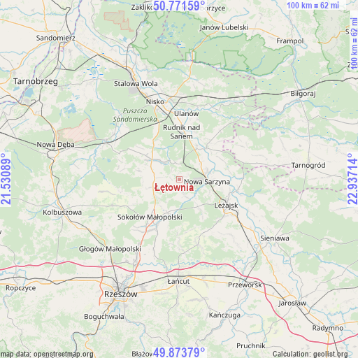
Łętownia GPS coordinates[2]
50° 19' 29.316" North, 22° 14' 2.436" East
| Map corner | latitude | longitude |
|---|---|---|
| Upper-left | 50.77159°, | 21.53089° |
| Center: | 50.32481°, | 22.23401° |
| Lower-right: | 49.87379°, | 22.93714° |
| Map W x H: | 99.8×99.8 km | = 62×62mi |
| max Lat: | 54.83135° ⇑71.5% North |
| Łętownia: | 50.32481° |
| min Lat: | ⇓28.5% South 49.21328° |
| min Long | Łętownia | max Long |
| 14.20249° | 22.23401° | 24.03723° |
| W 87.8%⇐ | ⇒12.2% E |
Elevation
Elevation of Łętownia is 190 m = 623 ft, and this is 1.4 m = 5 ft below average elevation for this country.
| Max E: |
974 m = 3196 ft | 43.2% |
| Avg. | 191.4 m = 628 ft | |
| Łętownia | 190 m = 623 ft | |
Min E: |
-3 m = -10 ft | 56.8% |
See also: Poland elevation on elevation.city.
Geographical zone
Łętownia is located in North temperate zone (between Tropic of Cancer and the Arctic Circle). Distance of this North polar circle is 1805.6 km =1121.9 mi to North.| Distance of | km | miles | from Łętownia |
|---|---|---|---|
| North Pole | 4411.5 | 2741.2 | to North |
| Arctic Circle | 1805.6 | 1121.9 | to North |
| Tropic Cancer | 2989.7 | 1857.7 | to South |
| Equator | 5595.6 | 3476.9 | to South |


Nearby cities:
15 places around Łętownia: (largest is in red/bold)
• Brzóza Królewska
11.5 km =7.1 mi,  145°
145°
• Cholewiana Góra
11.6 km =7.2 mi,  283°
283°
• Górno
7.9 km =4.9 mi,  233°
233°
• Hucisko
7 km =4.3 mi,  138°
138°
• Jeżowe
9.4 km =5.8 mi,  306°
306°
• Kamień
7.2 km =4.5 mi, 284°
• Kończyce
12.6 km =7.8 mi,  333°
333°
• Krzeszów
11.7 km =7.3 mi,  41°
41°
• Nowa Sarzyna
7.9 km =4.9 mi,  93°
93°
• Przychojec
12.3 km =7.6 mi,  103°
103°
• Tarnogóra
7.7 km =4.8 mi,  50°
50°
• Wola Żarczycka
3.9 km =2.4 mi,  162°
162°
• Wólka Niedźwiedzka
9.7 km =6 mi,  199°
199°
• Wólka Łętowska
1.9 km =1.2 mi,  265°
265°
• Łukowa
9.7 km =6 mi, 89°
Sources, notices
• [Note1] Compared only with cities in Poland existing in our database
• [Src1] Map data: © OpenStreetMap contributors (CC-BY-SA)
• [Src2] Other city data from geonames.org with taken over terms of usage.
• [Src3] Geographical zone / Annual Mean Temperature by Robert A. Rohde @ Wikipedia
