Żołynia geodata
Żołynia (Subcarpathian) is a seat of a third-order administrative division; located in Poland in Europe/Warsaw (GMT+2) time zone. With population of 5,145 people, there are 671 cities with bigger population in this country. Compared to other cities in Poland, 75.5% of cities are located further ↑North; 89% of cities are located further ←West and 63.3% of cities have lower elevation than Żołynia. Note1


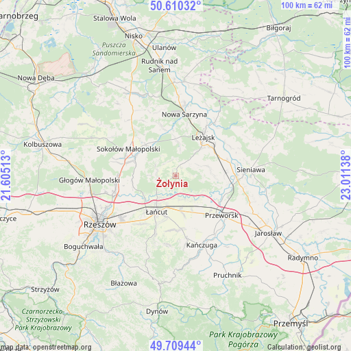
Żołynia GPS coordinates[2]
50° 9' 43.2" North, 22° 18' 29.7" East
| Map corner | latitude | longitude |
|---|---|---|
| Upper-left | 50.61032°, | 21.60513° |
| Center: | 50.162°, | 22.30825° |
| Lower-right: | 49.70944°, | 23.01138° |
| Map W x H: | 100.2×100.2 km | = 62.3×62.3mi |
| max Lat: | 54.83135° ⇑75.5% North |
| Żołynia: | 50.162° |
| min Lat: | ⇓24.5% South 49.21328° |
| min Long | Żołynia | max Long |
| 14.20249° | 22.30825° | 24.03723° |
| W 89%⇐ | ⇒11% E |
Elevation
Elevation of Żołynia is 210 m = 689 ft, and this is 18.6 m = 61 ft above average elevation for this country.
| Max E: |
974 m = 3196 ft | 36.7% |
| Żołynia | 210 m 689 ft | |
| Avg. | 191.4 m = 628 ft | |
Min E: |
-3 m = -10 ft | 63.3% |
See also: Poland elevation on elevation.city.
Geographical zone
Żołynia is located in North temperate zone (between Tropic of Cancer and the Arctic Circle). Distance of this North polar circle is 1823.7 km =1133.2 mi to North.| Distance of | km | miles | from Żołynia |
|---|---|---|---|
| North Pole | 4429.6 | 2752.4 | to North |
| Arctic Circle | 1823.7 | 1133.2 | to North |
| Tropic Cancer | 2971.6 | 1846.5 | to South |
| Equator | 5577.5 | 3465.7 | to South |


Nearby cities:
15 places around Żołynia: (largest is in red/bold)
• Białobrzegi
6.7 km =4.2 mi,  173°
173°
• Brzóza Królewska
8.7 km =5.4 mi,  8°
8°
• Brzóza Stadnicka
4.6 km =2.9 mi,  336°
336°
• Czarna
10.7 km =6.6 mi,  237°
237°
• Giedlarowa
10 km =6.2 mi,  43°
43°
• Grodzisko Dolne
11 km =6.8 mi,  89°
89°
• Grodzisko Górne
9.6 km =6 mi,  73°
73°
• Głuchów
9.3 km =5.8 mi,  196°
196°
• Kosina
10.1 km =6.3 mi, 171°
• Rakszawa
4.9 km =3 mi,  268°
268°
• Rogóźno
10.9 km =6.8 mi,  154°
154°
• Sonina
11.6 km =7.2 mi, 195°
• Wólka Grodziska
7.3 km =4.5 mi, 65°
• Wólka Niedźwiedzka
12.4 km =7.7 mi,  316°
316°
• Łańcut
11.8 km =7.3 mi,  208°
208°
Sources, notices
• [Note1] Compared only with cities in Poland existing in our database
• [Src1] Map data: © OpenStreetMap contributors (CC-BY-SA)
• [Src2] Other city data from geonames.org with taken over terms of usage.
• [Src3] Geographical zone / Annual Mean Temperature by Robert A. Rohde @ Wikipedia
