Kamień geodata
Kamień (Subcarpathian) is a seat of a third-order administrative division; located in Poland in Europe/Warsaw (GMT+2) time zone. With population of 2,700 people, there are 1159 cities with bigger population in this country. Compared to other cities in Poland, 71% of cities are located further ↑North; 86.6% of cities are located further ←West and 57.7% of cities have lower elevation than Kamień. Note1


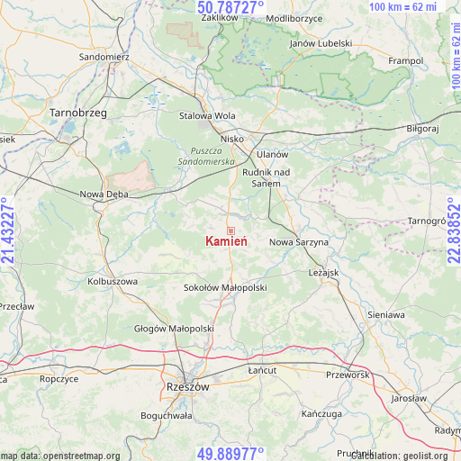
Kamień GPS coordinates[2]
50° 20' 26.304" North, 22° 8' 7.404" East
| Map corner | latitude | longitude |
|---|---|---|
| Upper-left | 50.78727°, | 21.43227° |
| Center: | 50.34064°, | 22.13539° |
| Lower-right: | 49.88977°, | 22.83852° |
| Map W x H: | 99.8×99.8 km | = 62×62mi |
| max Lat: | 54.83135° ⇑71% North |
| Kamień: | 50.34064° |
| min Lat: | ⇓29% South 49.21328° |
| min Long | Kamień | max Long |
| 14.20249° | 22.13539° | 24.03723° |
| W 86.6%⇐ | ⇒13.4% E |
Elevation
Elevation of Kamień is 193 m = 633 ft, and this is 1.6 m = 5 ft above average elevation for this country.
| Max E: |
974 m = 3196 ft | 42.3% |
| Kamień | 193 m 633 ft | |
| Avg. | 191.4 m = 628 ft | |
Min E: |
-3 m = -10 ft | 57.7% |
See also: Poland elevation on elevation.city.
Geographical zone
Kamień is located in North temperate zone (between Tropic of Cancer and the Arctic Circle). Distance of this North polar circle is 1803.8 km =1120.8 mi to North.| Distance of | km | miles | from Kamień |
|---|---|---|---|
| North Pole | 4409.7 | 2740.1 | to North |
| Arctic Circle | 1803.8 | 1120.8 | to North |
| Tropic Cancer | 2991.4 | 1858.8 | to South |
| Equator | 5597.4 | 3478.1 | to South |


Nearby cities:
15 places around Kamień: (largest is in red/bold)
• Cholewiana Góra
4.4 km =2.7 mi,  283°
283°
• Gwoździec
11 km =6.8 mi,  290°
290°
• Górno
6.5 km =4 mi,  173°
173°
• Hucisko
13.6 km =8.5 mi,  121°
121°
• Jeżowe
3.8 km =2.4 mi,  351°
351°
• Kończyce
9.6 km =6 mi,  7°
7°
• Nowa Sarzyna
15 km =9.3 mi,  98°
98°
• Raniżów
14.8 km =9.2 mi,  231°
231°
• Rudnik nad Sanem
13.8 km =8.6 mi,  35°
35°
• Sokołów Małopolski
12.5 km =7.8 mi,  185°
185°
• Tarnogóra
13.3 km =8.3 mi,  76°
76°
• Wola Żarczycka
9.8 km =6.1 mi, 123°
• Wólka Niedźwiedzka
11.6 km =7.2 mi,  161°
161°
• Wólka Łętowska
5.4 km =3.4 mi,  110°
110°
• Łętownia
7.2 km =4.5 mi, 104°
Sources, notices
• [Note1] Compared only with cities in Poland existing in our database
• [Src1] Map data: © OpenStreetMap contributors (CC-BY-SA)
• [Src2] Other city data from geonames.org with taken over terms of usage.
• [Src3] Geographical zone / Annual Mean Temperature by Robert A. Rohde @ Wikipedia
