Rakszawa geodata
Rakszawa (Subcarpathian) is a seat of a third-order administrative division; located in Poland in Europe/Warsaw (GMT+2) time zone. With population of 6,894 people, there are 548 cities with bigger population in this country. Compared to other cities in Poland, 75.6% of cities are located further ↑North; 87.8% of cities are located further ←West and 65.3% of cities have lower elevation than Rakszawa. Note1


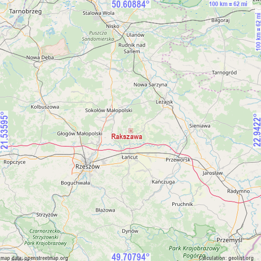
Rakszawa GPS coordinates[2]
50° 9' 37.836" North, 22° 14' 20.652" East
| Map corner | latitude | longitude |
|---|---|---|
| Upper-left | 50.60884°, | 21.53595° |
| Center: | 50.16051°, | 22.23907° |
| Lower-right: | 49.70794°, | 22.9422° |
| Map W x H: | 100.2×100.2 km | = 62.3×62.3mi |
| max Lat: | 54.83135° ⇑75.6% North |
| Rakszawa: | 50.16051° |
| min Lat: | ⇓24.4% South 49.21328° |
| min Long | Rakszawa | max Long |
| 14.20249° | 22.23907° | 24.03723° |
| W 87.8%⇐ | ⇒12.2% E |
Elevation
Elevation of Rakszawa is 215 m = 705 ft, and this is 23.6 m = 77 ft above average elevation for this country.
| Max E: |
974 m = 3196 ft | 34.7% |
| Rakszawa | 215 m 705 ft | |
| Avg. | 191.4 m = 628 ft | |
Min E: |
-3 m = -10 ft | 65.3% |
See also: Poland elevation on elevation.city.
Geographical zone
Rakszawa is located in North temperate zone (between Tropic of Cancer and the Arctic Circle). Distance of this North polar circle is 1823.8 km =1133.3 mi to North.| Distance of | km | miles | from Rakszawa |
|---|---|---|---|
| North Pole | 4429.7 | 2752.5 | to North |
| Arctic Circle | 1823.8 | 1133.3 | to North |
| Tropic Cancer | 2971.4 | 1846.3 | to South |
| Equator | 5577.3 | 3465.6 | to South |


Nearby cities:
15 places around Rakszawa: (largest is in red/bold)
• Białobrzegi
8.6 km =5.3 mi,  138°
138°
• Brzóza Królewska
10.7 km =6.6 mi,  35°
35°
• Brzóza Stadnicka
5.3 km =3.3 mi, 35°
• Czarna
7 km =4.3 mi,  215°
215°
• Głuchów
9.1 km =5.7 mi,  165°
165°
• Kosina
11.7 km =7.3 mi,  146°
146°
• Krzemienica
11.7 km =7.3 mi,  200°
200°
• Sokołów Małopolski
11.4 km =7.1 mi,  311°
311°
• Sonina
11.2 km =7 mi, 170°
• Wysoka
13 km =8.1 mi, 173°
• Wólka Grodziska
12 km =7.5 mi,  74°
74°
• Wólka Niedźwiedzka
9.8 km =6.1 mi,  338°
338°
• Wólka Podleśna
10.2 km =6.3 mi,  242°
242°
• Łańcut
10.2 km =6.3 mi,  183°
183°
• Żołynia
4.9 km =3 mi,  88°
88°
Sources, notices
• [Note1] Compared only with cities in Poland existing in our database
• [Src1] Map data: © OpenStreetMap contributors (CC-BY-SA)
• [Src2] Other city data from geonames.org with taken over terms of usage.
• [Src3] Geographical zone / Annual Mean Temperature by Robert A. Rohde @ Wikipedia
