Górno geodata
Górno (Subcarpathian) is a populated place; located in Poland in Europe/Warsaw (GMT+2) time zone. With population of 1,898 people, there are 1562 cities with bigger population in this country. Compared to other cities in Poland, 72.5% of cities are located further ↑North; 86.8% of cities are located further ←West and 65.9% of cities have lower elevation than Górno. Note1
Administrative division(s):
- Level 1: Subcarpathian
- Level 2: Powiat rzeszowski
- Level 3: Sokołów Małopolski


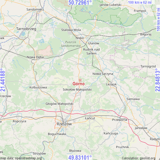
Górno GPS coordinates[2]
50° 16' 56.748" North, 22° 8' 42" East
| Map corner | latitude | longitude |
|---|---|---|
| Upper-left | 50.72961°, | 21.44188° |
| Center: | 50.28243°, | 22.145° |
| Lower-right: | 49.83101°, | 22.84813° |
| Map W x H: | 99.9×99.9 km | = 62.1×62.1mi |
| max Lat: | 54.83135° ⇑72.5% North |
| Górno: | 50.28243° |
| min Lat: | ⇓27.5% South 49.21328° |
| min Long | Górno | max Long |
| 14.20249° | 22.145° | 24.03723° |
| W 86.8%⇐ | ⇒13.2% E |
Elevation
Elevation of Górno is 216 m = 709 ft, and this is 24.6 m = 81 ft above average elevation for this country.
| Max E: |
974 m = 3196 ft | 34.1% |
| Górno | 216 m 709 ft | |
| Avg. | 191.4 m = 628 ft | |
Min E: |
-3 m = -10 ft | 65.9% |
See also: Poland elevation on elevation.city.
Geographical zone
Górno is located in North temperate zone (between Tropic of Cancer and the Arctic Circle). Distance of this North polar circle is 1810.3 km =1124.9 mi to North.| Distance of | km | miles | from Górno |
|---|---|---|---|
| North Pole | 4416.2 | 2744.1 | to North |
| Arctic Circle | 1810.3 | 1124.9 | to North |
| Tropic Cancer | 2985 | 1854.8 | to South |
| Equator | 5590.9 | 3474 | to South |


Nearby cities:
15 places around Górno: (largest is in red/bold)
• Brzóza Królewska
13.7 km =8.5 mi,  110°
110°
• Brzóza Stadnicka
13.4 km =8.3 mi,  133°
133°
• Cholewiana Góra
9 km =5.6 mi,  326°
326°
• Gwoździec
15.1 km =9.4 mi,  313°
313°
• Hucisko
11 km =6.8 mi,  92°
92°
• Jeżowe
10.4 km =6.5 mi,  353°
353°
• Kamień
6.5 km =4 mi, 353°
• Nowa Sarzyna
14.8 km =9.2 mi,  73°
73°
• Rakszawa
15.1 km =9.4 mi,  153°
153°
• Raniżów
12.6 km =7.8 mi,  257°
257°
• Sokołów Małopolski
6.2 km =3.9 mi,  196°
196°
• Wola Żarczycka
7.5 km =4.7 mi,  82°
82°
• Wólka Niedźwiedzka
5.4 km =3.4 mi, 145°
• Wólka Łętowska
6.3 km =3.9 mi,  44°
44°
• Łętownia
7.9 km =4.9 mi,  53°
53°
Sources, notices
• [Note1] Compared only with cities in Poland existing in our database
• [Src1] Map data: © OpenStreetMap contributors (CC-BY-SA)
• [Src2] Other city data from geonames.org with taken over terms of usage.
• [Src3] Geographical zone / Annual Mean Temperature by Robert A. Rohde @ Wikipedia
