Lipnik geodata
Lipnik (Świętokrzyskie) is a seat of a third-order administrative division; located in Poland in Europe/Warsaw (GMT+2) time zone. With population of 400 people, there are 3589 cities with bigger population in this country. Compared to other cities in Poland, 62% of cities are located further ↑North; 79.1% of cities are located further ←West and 77.6% of cities have lower elevation than Lipnik. Note1


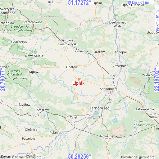
Lipnik GPS coordinates[2]
50° 43' 47.172" North, 21° 29' 38.004" East
| Map corner | latitude | longitude |
|---|---|---|
| Upper-left | 51.17272°, | 20.79077° |
| Center: | 50.72977°, | 21.49389° |
| Lower-right: | 50.28259°, | 22.19702° |
| Map W x H: | 99×99 km | = 61.5×61.5mi |
| max Lat: | 54.83135° ⇑62% North |
| Lipnik: | 50.72977° |
| min Lat: | ⇓38% South 49.21328° |
| min Long | Lipnik | max Long |
| 14.20249° | 21.49389° | 24.03723° |
| W 79.1%⇐ | ⇒20.9% E |
Elevation
Elevation of Lipnik is 256 m = 840 ft, and this is 64.6 m = 212 ft above average elevation for this country.
| Max E: |
974 m = 3196 ft | 22.4% |
| Lipnik | 256 m 840 ft | |
| Avg. | 191.4 m = 628 ft | |
Min E: |
-3 m = -10 ft | 77.6% |
See also: Poland elevation on elevation.city.
Geographical zone
Lipnik is located in North temperate zone (between Tropic of Cancer and the Arctic Circle). Distance of this North polar circle is 1760.6 km =1094 mi to North.| Distance of | km | miles | from Lipnik |
|---|---|---|---|
| North Pole | 4366.4 | 2713.2 | to North |
| Arctic Circle | 1760.6 | 1094 | to North |
| Tropic Cancer | 3034.7 | 1885.7 | to South |
| Equator | 5640.6 | 3504.9 | to South |


Nearby cities:
15 places around Lipnik: (largest is in red/bold)
• Bogoria
18.6 km =11.6 mi,  242°
242°
• Brzóstowa
17.9 km =11.1 mi,  357°
357°
• Iwaniska
15 km =9.3 mi,  270°
270°
• Klimontów
8.6 km =5.3 mi,  198°
198°
• Koprzywnica
16.4 km =10.2 mi,  157°
157°
• Obrazów
11.8 km =7.3 mi,  110°
110°
• Opatów
9.2 km =5.7 mi,  328°
328°
• Sadowie
16.2 km =10.1 mi, 327°
• Samborzec
14.3 km =8.9 mi,  130°
130°
• Sobótka
14.8 km =9.2 mi,  60°
60°
• Wilczyce
11.7 km =7.3 mi,  80°
80°
• Wojciechowice
14.2 km =8.8 mi,  28°
28°
• Złota
15.3 km =9.5 mi,  119°
119°
• Ćmielów
17.9 km =11.1 mi,  4°
4°
• Łoniów
18.5 km =11.5 mi,  172°
172°
Sources, notices
• [Note1] Compared only with cities in Poland existing in our database
• [Src1] Map data: © OpenStreetMap contributors (CC-BY-SA)
• [Src2] Other city data from geonames.org with taken over terms of usage.
• [Src3] Geographical zone / Annual Mean Temperature by Robert A. Rohde @ Wikipedia
