Opatów geodata
Opatów (Świętokrzyskie) is a seat of a second-order administrative division; located in Poland in Europe/Warsaw (GMT+2) time zone. With population of 6,799 people, there are 554 cities with bigger population in this country. Compared to other cities in Poland, 60.1% of cities are located further ↑North; 78.4% of cities are located further ←West and 69.4% of cities have lower elevation than Opatów. Note1


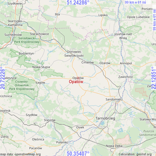
Opatów GPS coordinates[2]
50° 48' 2.088" North, 21° 25' 31.368" East
| Map corner | latitude | longitude |
|---|---|---|
| Upper-left | 51.24286°, | 20.72226° |
| Center: | 50.80058°, | 21.42538° |
| Lower-right: | 50.35407°, | 22.12851° |
| Map W x H: | 98.8×98.8 km | = 61.4×61.4mi |
| max Lat: | 54.83135° ⇑60.1% North |
| Opatów: | 50.80058° |
| min Lat: | ⇓39.9% South 49.21328° |
| min Long | Opatów | max Long |
| 14.20249° | 21.42538° | 24.03723° |
| W 78.4%⇐ | ⇒21.6% E |
Elevation
Elevation of Opatów is 227 m = 745 ft, and this is 35.6 m = 117 ft above average elevation for this country.
| Max E: |
974 m = 3196 ft | 30.6% |
| Opatów | 227 m 745 ft | |
| Avg. | 191.4 m = 628 ft | |
Min E: |
-3 m = -10 ft | 69.4% |
See also: Poland elevation on elevation.city.
Geographical zone
Opatów is located in North temperate zone (between Tropic of Cancer and the Arctic Circle). Distance of this North polar circle is 1752.7 km =1089.1 mi to North.| Distance of | km | miles | from Opatów |
|---|---|---|---|
| North Pole | 4358.6 | 2708.3 | to North |
| Arctic Circle | 1752.7 | 1089.1 | to North |
| Tropic Cancer | 3042.6 | 1890.6 | to South |
| Equator | 5648.5 | 3509.8 | to South |


Nearby cities:
15 places around Opatów: (largest is in red/bold)
• Baćkowice
13.6 km =8.5 mi,  265°
265°
• Bodzechów
11.9 km =7.4 mi,  3°
3°
• Brzóstowa
10.8 km =6.7 mi,  21°
21°
• Grójec
11.4 km =7.1 mi, 17°
• Iwaniska
12.8 km =8 mi,  232°
232°
• Klimontów
16.2 km =10.1 mi,  172°
172°
• Lipnik
9.2 km =5.7 mi,  148°
148°
• Ostrowiec Świętokrzyski
14.6 km =9.1 mi,  348°
348°
• Ożarów
19.5 km =12.1 mi,  60°
60°
• Sadowie
7 km =4.3 mi,  325°
325°
• Sobótka
17.6 km =10.9 mi,  91°
91°
• Waśniów
17.9 km =11.1 mi,  307°
307°
• Wilczyce
17.4 km =10.8 mi,  110°
110°
• Wojciechowice
12.4 km =7.7 mi,  68°
68°
• Ćmielów
11.8 km =7.3 mi,  32°
32°
Sources, notices
• [Note1] Compared only with cities in Poland existing in our database
• [Src1] Map data: © OpenStreetMap contributors (CC-BY-SA)
• [Src2] Other city data from geonames.org with taken over terms of usage.
• [Src3] Geographical zone / Annual Mean Temperature by Robert A. Rohde @ Wikipedia
